

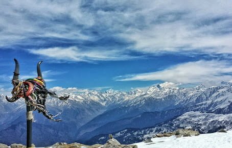
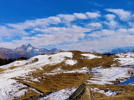
“Bugyals” are high altitude meadows found in the Indian state of Uttarakhand. These grassy plains, also known as alpine meadows, are found at elevations above 3,000 meters (9,800 feet) in the Himalayan mountain range and are known for their stunning natural beauty. They are often covered in wildflowers and provide a habitat for a variety of animal species. Bugyals are a popular destination for trekking and other outdoor activities, and are an important part of the local culture and economy in Uttarakhand.
There are many bugyals located in the Himalayan mountain range in Uttarakhand, and some of the well-known ones include:
- Auli Bugyal
- Bedini Bugyal
- Dayara Bugyal
- Gorson Bugyal
- Kandoliya Bugyal
- Khaliya Top Bugyal
- Madhmaheshwar Bugyal
- Neel Ganga Bugyal
- Raithal Bugyal
- Tapovan Bugyal
Auli Bugyal
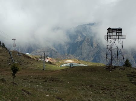
Auli Bugyal is a high altitude meadow located in the Indian state of Uttarakhand, in the Himalayan mountain range. It is situated at an elevation of about 3,050 meters (10,000 feet) above sea level, and is known for its beautiful natural surroundings and panoramic views of the surrounding peaks. Auli Bugyal is a popular destination for trekking, skiing, and other outdoor activities. It is also home to a number of temples and other cultural sites. During the winter months, the meadow is often covered in snow and is a popular destination for skiing. The ski season typically runs from December to March, and the slopes are equipped with chair lifts and other ski infrastructure.

Suggested Detailed Auli Bugyal Trekking Itinerary
Here is a suggested 7-day itinerary for a trek to Auli Bugyal:
Day 1: Arrive in Joshimath and acclimatize
- On the first day, you will arrive in Joshimath, a town located near Auli Bugyal. You can spend the day exploring the town and acclimatizing to the high altitude.
Day 2: Trek to Gurson Bugyal (3,056 meters/10,023 feet)
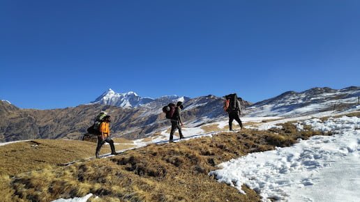
- From Joshimath, you will begin your trek to Auli Bugyal by first making your way to Gurson Bugyal, a nearby meadow. The trek to Gurson Bugyal takes about 5-6 hours and is classified as moderate in difficulty.
Day 3: Trek to Auli Bugyal (3,050 meters/10,000 feet)
- From Gurson Bugyal, you will continue your trek to Auli Bugyal. The trek takes about 6-7 hours and is classified as moderate in difficulty. Along the way, you will pass through forests of oak and rhododendron and have the opportunity to take in beautiful views of the surrounding peaks.
Day 4: Rest day in Auli Bugyal
- On this day, you can take a break from trekking and explore the meadow. You can go sightseeing or try your hand at skiing, if you are there during the winter months.
Day 5: Trek to Khulara (3,056 meters/10,023 feet)
- From Auli Bugyal, you will begin your journey back to Joshimath by trekking to Khulara. The trek takes about 6-7 hours and is classified as moderate in difficulty.
Day 6: Trek to Gurson Bugyal
- From Khulara, you will continue your trek to Gurson Bugyal. The trek takes about 6-7 hours and is classified as moderate in difficulty.
Day 7: Trek to Joshimath and depart
- On the final day of the trek, you will make your way back to Joshimath, where you can catch a bus or taxi back to your starting point.
This itinerary is just a suggestion, and you can adjust the duration and route of the trek to suit your needs and preferences. It is important to be well-prepared for the trek and to be aware of your own physical limitations. Make sure to bring plenty of water, snacks, and warm clothing, and be sure to listen to your guide and follow their instructions.
A Beginner’s Guide to Trekking in Auli Bugyal
Auli Bugyal is a stunning high altitude meadow located in the Indian state of Uttarakhand, in the Himalayan mountain range. With its rolling grassy plains, wildflowers, and panoramic views of the surrounding peaks, it’s no wonder that Auli Bugyal is a popular destination for trekkers. If you’re planning a trek to Auli Bugyal, here are a few tips to help you get started.
When to Go:
The best time to trek to Auli Bugyal depends on what you’re looking for. If you’re interested in skiing, the winter months (December to March) are the best time to go. During this time, the meadow is covered in snow and the slopes are open for skiing. If you prefer to hike, the summer months (May to September) are the best time to go, as the weather is generally mild and the trails are less crowded.
What to Pack:
Be sure to pack wisely for your trek to Auli Bugyal. The weather can change quickly in the mountains, so it’s important to bring warm, waterproof clothing. Pack layers that you can easily add or remove as needed. It’s also a good idea to bring plenty of water, snacks, and a first aid kit. Other essential items to bring include a sturdy pair of hiking boots, a hat, sunscreen, and insect repellent.
Preparing for High Altitude:
Auli Bugyal is located at an elevation of about 3,050 meters (10,000 feet) above sea level, so it’s important to prepare for the effects of high altitude. To help prevent altitude sickness, it’s a good idea to acclimatize by spending a day or two in Joshimath (located at an elevation of about 2,050 meters/6,725 feet) before starting your trek. During the trek, take it slow and listen to your body. If you start to feel lightheaded or dizzy, stop and rest until you feel better. It’s also a good idea to drink plenty of water and avoid alcohol while at high altitude.
With these tips in mind, you’ll be well on your way to a successful and enjoyable trek to Auli Bugyal. Happy trails!
Exploring the Culture and History of Auli Bugyal
Auli Bugyal is a beautiful high altitude meadow located in the Indian state of Uttarakhand, in the Himalayan mountain range. In addition to its natural beauty, Auli Bugyal is also rich in culture and history. Here’s a closer look at some of the cultural and historical highlights of this stunning destination.
Importance to the Local Community:
For centuries, Auli Bugyal has been an important part of the local culture and economy in Uttarakhand. The meadow is used for grazing livestock and is also a popular destination for trekking and other outdoor activities. The local community relies on the tourism industry to support their livelihoods, and many of the trekking guides and other service providers in the area are from the local community.
Temples and Cultural Sites:
In addition to its natural beauty, Auli Bugyal is home to a number of temples and other cultural sites. One of the most well-known temples in the area is the Auli Temple, which is dedicated to the Hindu god Vishnu. The temple is believed to have been built in the 8th century and is known for its beautiful architecture and panoramic views of the surrounding peaks. Other cultural sites in the area include the Narsingh Temple, the Rudranath Temple, and the Badrinath Temple, all of which are considered sacred by the local community.
History of Auli Bugyal:
Auli Bugyal has a long and fascinating history. The meadow is believed to have been a popular destination for Buddhist monks and scholars in ancient times, and there are a number of ancient Buddhist monasteries and temples in the area. In more recent history, Auli Bugyal was discovered by British colonial officials in the 19th century and became a popular destination for European travelers. Today, Auli Bugyal is a popular destination for both domestic and international travelers and is an important part of the local culture and economy in Uttarakhand.
With its beautiful natural surroundings, rich cultural history, and important role in the local community, Auli Bugyal is a truly special destination. Whether you’re interested in exploring the temples and cultural sites, trying your hand at skiing, or simply taking in the breathtaking views, there’s something for everyone in this stunning mountain meadow.
Off the Beaten Path: Hidden Gems in Auli Bugyal
Auli Bugyal is a beautiful high altitude meadow, in the Himalayan mountain range. While it’s well-known for its stunning natural beauty and popular ski slopes, there are many hidden gems in Auli Bugyal that may be overlooked by many travelers. Here are a few lesser-known or less-visited spots in Auli Bugyal that are worth seeking out.
- Kunth Khal: Kunth Khal is a small lake located near Auli Bugyal. It’s a peaceful and serene spot, surrounded by forests of oak and rhododendron. The lake is a popular spot for picnics and is also a good place to spot local wildlife.
- Narsingh Temple: The Narsingh Temple is a little-known cultural site located in Auli Bugyal. The temple is dedicated to the Hindu god Narsingh, and is believed to be more than 2,000 years old. It’s a peaceful and serene spot, and the views from the temple are stunning.
- Gurson Bugyal: Gurson Bugyal is a nearby meadow that is often overlooked by travelers to Auli Bugyal. It’s a beautiful spot, with rolling grassy plains and panoramic views of the surrounding peaks. Gurson Bugyal is a great place for a leisurely hike or a picnic.
- Tapovan: Tapovan is a small village located near Auli Bugyal. It’s a picturesque spot, with traditional stone houses and beautiful views of the surrounding mountains. Tapovan is a good place to get a sense of the local culture and to meet the friendly people of Uttarakhand.
Whether you’re interested in peaceful lakes, cultural sites, or charming villages, there are plenty of hidden gems to discover in Auli Bugyal. Take some time to explore off the beaten path and you’ll be rewarded with some truly special experiences.
Stay in Auli bugyal
- GMVN Tourist Bungalow: Located in the heart of Auli Bugyal, this budget-friendly guesthouse offers simple rooms with shared bathrooms. The guesthouse has a restaurant and a common area with a fireplace.
- Auli Hilltop: This mid-range hotel is located in Auli Bugyal and offers comfortable rooms with private bathrooms and mountain views. The hotel has a restaurant, a spa, and a sauna.
- Auli Ski and Snowboard Resort: This luxury resort is located in Auli Bugyal and offers spacious rooms and suites with private balconies and mountain views. The resort has a restaurant, a bar, a spa, and a fitness center.
- Auli Lifestyle Resort: This luxury resort is located in Auli Bugyal and offers spacious rooms and suites with private balconies and mountain views. The resort has a restaurant, a bar, a spa, and a fitness center.
When booking accommodation in Auli Bugyal, be sure to consider the time of year you’ll be visiting, as prices and availability may vary depending on the season. It’s also a good idea to book ahead, as the best accommodations can fill up quickly.
Best time to visit Auli Bugyal
The best time to visit Auli Bugyal depends on what you’re looking for. Here are a few things to consider:
- If you’re interested in skiing: The winter months (December to March) are the best time to visit Auli Bugyal for skiing. During this time, the meadow is covered in snow and the slopes are open for skiing.
- If you prefer warm weather: The summer months (May to September) are the best time to visit Auli Bugyal if you prefer warmer temperatures. During this time, the weather is generally mild and there are plenty of opportunities for hiking and other outdoor activities.
- If you want to avoid crowds: The shoulder seasons (April and October) are a good time to visit Auli Bugyal if you want to avoid the crowds. During these months, the weather is generally pleasant and the trails are less crowded.
No matter when you visit Auli Bugyal, be sure to bring warm, waterproof clothing, as the weather can change quickly in the mountains
Bedini Bugyal
Bedini Bugyal is a high altitude meadow located in the Indian state of Uttarakhand, in the Himalayan mountain range. It is situated at an elevation of about 3,049 meters (10,000 feet) above sea level and is known for its rolling grassy plains, wildflowers, and panoramic views of the surrounding peaks. Bedini Bugyal is a popular destination for trekking and other outdoor activities, and it is also home to a number of temples and cultural sites. The meadow is located near the town of Joshimath and is accessible by foot or by local bus from Joshimath.

A travel guide to Bedni Bugyal:
- How to reach Bedni Bugyal: Bedni Bugyal can be reached by road or by trek. If you are driving, you can reach Bedni Bugyal from Rishikesh or Dehradun, which are well connected to major cities in India by road. From Rishikesh or Dehradun, you will have to drive to the town of Karnaprayag, and then take a small detour to reach the base of the Bedni Bugyal trek. The trek to Bedni Bugyal starts from Lohajung, which is the last roadhead on this route.
- Best time to visit Bedni Bugyal: The best time to visit Bedni Bugyal is from April to June and September to November. These months offer pleasant weather and clear skies, making it ideal for trekking and other outdoor activities. However, it is important to note that the weather in the Himalayas can be unpredictable, and it can get quite cold at night even during the summer months. So, it is always a good idea to carry warm clothing and be prepared for changes in the weather.
- Things to do at Bedni Bugyal: Bedni Bugyal is a paradise for nature lovers and outdoor enthusiasts. Some of the activities that visitors can enjoy at Bedni Bugyal are:
- Trekking: The Bedni Bugyal trek is a moderate to difficult trek that takes you through some of the most beautiful landscapes in the Himalayas. The trek starts from Lohajung and takes you through forests, streams, and meadows, culminating at Bedni Bugyal.
- Photography: The natural beauty of Bedni Bugyal is a photographer’s delight. From the stunning views of the Himalayan peaks to the colorful wildflowers that bloom in the meadow, there is no shortage of photo opportunities at Bedni Bugyal.
- Birdwatching: Bedni Bugyal is home to a variety of birds, including the Himalayan Monal, which is the state bird of Uttarakhand. Birdwatchers can spot a variety of birds at Bedni Bugyal, including pheasants, finches, and warblers.
A cultural exploration of Bedni Bugyal:
- Local culture and traditions: The region surrounding Bedni Bugyal is predominantly inhabited by people belonging to the Bhotiya community. The Bhotiyas are a Tibetan-speaking community and follow a unique culture and set of traditions that have been passed down through the generations. Some of the cultural practices followed by the Bhotiyas include:
- Chhoti Holi: Chhoti Holi is a festival that is celebrated by the Bhotiyas a few days before the Hindu festival of Holi. It is marked by singing, dancing, and the exchange of greetings and gifts.
- Birth and death rituals: The Bhotiyas follow a set of unique rituals to mark the birth and death of a person. These rituals involve the offering of prayers and the performance of certain ceremonies by a village priest.
- Marriage rituals: Marriage is an important milestone in the life of a Bhotiya person. The Bhotiyas follow a set of elaborate marriage rituals that involve the exchange of gifts, the performance of traditional songs and dances, and the offering of prayers.
- Local handicrafts and handicrafts: The Bhotiyas are skilled in the art of handicrafts, and the region surrounding Bedni Bugyal is home to a number of handicrafts. Some of the popular handicrafts of the region include:
- Woollen shawls: The Bhotiyas are known for their skills in spinning and weaving wool, and the region is home to a number of woollen shawls that are made using traditional techniques.
- Hand-woven baskets: The Bhotiyas are skilled in the art of basket weaving, and the region is home to a number of hand-woven baskets that are made using traditional techniques.
- Carpets and rugs: The Bhotiyas are skilled in the art of carpet weaving, and the region is home to a number of carpets and rugs that are made using traditional techniques.
An environmental analysis of Bedni Bugyal:
- The impact of tourism on the environment: Like any other popular tourist destination, Bedni Bugyal is also faced with the challenge of managing the impact of tourism on the environment. Some of the ways in which tourism can impact the environment at Bedni Bugyal are:
- Littering: One of the major problems faced by Bedni Bugyal is littering by tourists. This can not only mar the natural beauty of the place but also pose a threat to the local flora and fauna.
- Overcrowding: With an increase in the number of tourists visiting Bedni Bugyal, there is a risk of overcrowding, which can lead to the degradation of the natural surroundings.
- Deforestation: The demand for firewood and timber by tourists can lead to deforestation, which can have a negative impact on the local ecosystem.
- Steps being taken to protect and preserve the natural beauty of Bedni Bugyal: In order to protect and preserve the natural beauty of Bedni Bugyal, the following steps are being taken:
- Implementing a waste management system: The local authorities have implemented a waste management system at Bedni Bugyal, which involves the segregation and proper disposal of waste.
- Promoting eco-tourism: The authorities are promoting eco-tourism at Bedni Bugyal, which involves the adoption of sustainable tourism practices that have a minimal impact on the environment.
- Planting and nurturing trees: The authorities are planting and nurturing trees at Bedni Bugyal in order to restore the natural balance and improve the environment.
How to reach Bedni Bugyal
- By road:
- From Delhi: If you are coming from Delhi, you can reach Bedni Bugyal by taking a bus or hiring a taxi to Rishikesh or Dehradun, which are well connected to Delhi by road. From Rishikesh or Dehradun, you will have to drive to the town of Karnaprayag, and then take a small detour to reach the base of the Bedni Bugyal trek. The trek to Bedni Bugyal starts from Lohajung, which is the last roadhead on this route.
- From Rishikesh: If you are coming from Rishikesh, you can reach Bedni Bugyal by taking a bus or hiring a taxi to Karnaprayag. From Karnaprayag, you will have to take a small detour to reach the base of the Bedni Bugyal trek. The trek to Bedni Bugyal starts from Lohajung, which is the last roadhead on this route.
- By trek: If you are planning to trek to Bedni Bugyal, you can start the trek from Lohajung, which is the last roadhead on this route. The trek to Bedni Bugyal takes around 4-5 days to complete and involves walking for long hours on rough terrain. It is a moderate to difficult trek, depending on your fitness level and trekking experience.
Places to visit in Bedni Bugyal
- Bedni Bugyal: Bedni Bugyal is the main attraction of the region and offers stunning views of the Himalayan peaks. The meadow is covered with colorful wildflowers during the summer months and is a paradise for nature lovers.
- Roopkund Lake: Roopkund Lake is a high altitude glacial lake located near Bedni Bugyal. It is known for the hundreds of human skeletons that were discovered at the bottom of the lake, which are believed to belong to the 9th century AD.
- Ali Bugyal: Ali Bugyal is a high altitude meadow located near Bedni Bugyal. It is known for its natural beauty and is a popular spot for trekking and photography.
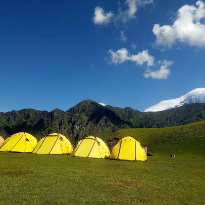
- Bhagwabasa: Bhagwabasa is a high altitude campsite located near Bedni Bugyal. It offers stunning views of the Himalayan peaks and is a popular spot for camping.
- Neel Ganga: Neel Ganga is a river that flows through the region surrounding Bedni Bugyal. It is a popular spot for picnics and offers a chance to relax in the natural surroundings.
Stay / Hotel in Bedni Bugyal
Here are some options for staying in Bedni Bugyal:
- Camping: Bedni Bugyal is a popular spot for camping, and there are several campsites in the region that offer tents and other camping equipment for rent. You can also bring your own camping gear and pitch a tent in a secluded spot in the meadow.
- Homestays: There are several homestays in the region surrounding Bedni Bugyal that offer basic accommodation facilities. Homestays are a good option if you are looking for a budget-friendly option and want to experience local hospitality.
- Hotels: There are a few hotels in the region surrounding Bedni Bugyal that offer comfortable accommodation facilities. These hotels usually have basic amenities such as electricity, hot water, and basic meals.
How difficult is Bedni Bugyal Trek?
The difficulty of the Ali Bedini Bugyal Trek depends on a number of factors, including your physical fitness level, your experience with trekking and high altitude, and the weather conditions. In general, the Ali Bedini Bugyal Trek is considered to be a moderate to challenging trek, as it involves a number of steep ascents and descents and can be physically demanding.
The trek starts in the town of Lohajung, at an elevation of about 2,057 meters (6,746 feet), and passes through a number of villages, forests, and meadows before reaching Ali Bedini Bugyal. Along the way, trekkers will have the opportunity to enjoy stunning views of the Himalayan peaks, as well as visit a number of temples and cultural sites.
To prepare for the trek, it’s a good idea to be in good physical shape, as the trek involves a lot of walking and can be physically demanding. It’s also a good idea to acclimatize to the high altitude before starting the trek, as the meadow is located at a high elevation and some people may be affected by altitude sickness.
Overall, the Ali Bedini Bugyal Trek is a rewarding and challenging trek that offers a unique opportunity to explore the beautiful landscape and culture of Uttarakhand.
Dayara Bugyal
Dayara Bugyal is a high altitude meadow located in the Indian state of Uttarakhand, in the Himalayan mountain range. It is situated at an elevation of about 3,049 meters (10,000 feet) above sea level and is known for its rolling grassy plains, wildflowers, and panoramic views of the surrounding peaks. Dayara Bugyal is a popular destination for trekking and other outdoor activities, and it is also home to a number of temples and cultural sites.
To reach Dayara Bugyal, you’ll need to fly to the nearest major airport in Delhi and then travel by road to the town of Rishikesh. From Rishikesh, you can take a bus or hire a car to reach the town of Uttarkashi, which is the nearest town to Dayara Bugyal. From Uttarkashi, you can either hike or hire a pony to reach the meadow.

Once you’re in Dayara Bugyal, there are a number of things to do and see. You can go trekking and explore the surrounding area, visit the local temples and cultural sites, or simply relax and take in the stunning views. The meadow is also a great place for picnics, birdwatching, and photography.
How to reach Dayara Bugyal
To reach Dayara Bugyal, you can follow these steps:
- Fly to Delhi: The nearest major airport to Dayara Bugyal is Indira Gandhi International Airport in Delhi. From Delhi, you can take a connecting flight or hire a car to reach the town of Rishikesh.
- Reach Rishikesh: Rishikesh is a town located in the state of Uttarakhand and is known as the “Yoga Capital of the World.” It is located about 260 kilometers (162 miles) from Delhi and is well-connected by road. You can hire a car or take a bus from Delhi to reach Rishikesh.
- Reach Uttarkashi: From Rishikesh, you can take a bus or hire a car to reach Uttarkashi, which is the nearest town to Dayara Bugyal. Uttarkashi is located about 215 kilometers (133 miles) from Rishikesh and is well-connected by road.
- Reach Dayara Bugyal: From Uttarkashi, you can hire a car or take a local bus to reach the town of Barsu, which is the starting point for the Dayara Bugyal Trek. From Barsu, you can either hike to Dayara Bugyal or hire a pony to reach the meadow.
A Beginner’s Guide to Trekking in Dayara Bugyal
Dayara Bugyal is a beautiful high altitude meadow located in the Indian state of Uttarakhand, in the Himalayan mountain range. With its rolling grassy plains, wildflowers, and panoramic views of the surrounding peaks, Dayara Bugyal is a popular destination for trekking and other outdoor activities. If you’re planning a trek to Dayara Bugyal, here’s a beginner’s guide to help you get started.
Best Time to Go:
The best time to visit Dayara Bugyal depends on your interests and the type of trek you’re planning. If you’re interested in skiing, the winter months (December to March) are the best time to visit, as the meadow is covered in snow and the slopes are open for skiing. If you prefer warmer weather, the summer months (May to September) are a good time to visit, as the weather is generally mild and there are plenty of opportunities for hiking and other outdoor activities. If you want to avoid the crowds, the shoulder seasons (April and October) are a good time to visit, as the weather is generally pleasant and the trails are less crowded.
What to Pack:
When packing for your trek to Dayara Bugyal, be sure to bring warm, waterproof clothing, as the weather can change quickly in the mountains. It’s also a good idea to bring plenty of water, snacks, and a first aid kit. Other items you may want to consider packing include a map, a compass, a flashlight, a multi-tool, and a headlamp. If you’re planning to spend the night in Dayara Bugyal, you’ll also need to bring a tent, a sleeping bag, and a sleeping pad.
How to Prepare:
To prepare for your trek to Dayara Bugyal, it’s a good idea to be in good physical shape, as the trek involves a lot of walking and can be physically demanding. It’s also a good idea to acclimatize to the high altitude before starting the trek, as the meadow is located at a high elevation and some people may be affected by altitude sickness. To acclimatize, it’s a good idea to spend a few days at lower elevations before starting the trek, and to take it easy for the first few days on the trail.
With these tips in mind, you’ll be well-prepared for an enjoyable and rewarding trek to Dayara Bugyal. So pack your bags, hit the trails, and get ready to explore one of the most beautiful destinations in the Himalayas.
Exploring the Culture and History of Dayara Bugyal
Dayara Bugyal is also rich in culture and history. Here’s a closer look at the local culture and history of this special place.
The Importance of Dayara Bugyal to the Local Community:
Dayara Bugyal has long been an important resource for the local community. In the summer months, the meadow is used for grazing livestock, and the villagers of Barsu and the surrounding area rely on the meadow for their livelihoods. Dayara Bugyal is also a popular destination for picnics and other outdoor activities, and the local community benefits from the tourism industry.
Temples and Cultural Sites:
Dayara Bugyal is home to a number of temples and cultural sites. The most well-known of these is the Dayara Temple, which is located near the meadow and is dedicated to the Hindu goddess Durga. The temple is believed to be more than 2,000 years old and is a popular spot for pilgrimage. Other temples in the area include the Bhairav Temple, the Raghunath Temple, and the Surya Temple. In addition to the temples, Dayara Bugyal is also home to a number of cultural sites, including the Dayara Fort and the Gurson Temple.
The History of Dayara Bugyal:
Dayara Bugyal has a long and rich history. The meadow is believed to have been a popular destination for travelers and traders for centuries, and there is evidence that it was an important stop on the ancient Silk Road. In more recent times, Dayara Bugyal has been a popular spot for trekking and other outdoor activities, and it has become an important part of the local economy.
Overall, Dayara Bugyal is a place that is rich in culture and history. Whether you’re interested in exploring the local temples and cultural sites, learning about the history of the area, or simply soaking up the local culture, Dayara Bugyal is a destination that offers something for everyone.
Off the Beaten Path: Hidden Gems in Dayara Bugyal
It will highlight some of the lesser-known or less-visited areas of Dayara Bugyal, including hidden trails, scenic viewpoints, or cultural sites that may be overlooked by many travelers.
Dayara Bugyal also has a number of hidden gems that are often overlooked by travelers. Here are a few off-the-beaten-path highlights that are worth discovering:
- Gurson Temple: Located near the village of Barsu, the Gurson Temple is a little-known temple that is dedicated to the Hindu deity Lord Shiva. The temple is located in a picturesque setting, surrounded by forests and meadows, and it offers beautiful views of the surrounding peaks.
- Dayara Fort: The Dayara Fort is a historical site that is located near the Dayara Temple. The fort is believed to have been built in the 14th century and is a testament to the area’s rich history. The fort offers panoramic views of the surrounding landscape and is a great spot for photography.
- Hidden Trails: Dayara Bugyal is surrounded by a network of trails that offer plenty of opportunities for exploration. Some of the trails are well-known and well-traveled, while others are more off the beaten path. If you’re looking to get away from the crowds, consider venturing onto one of the lesser-known trails, which often offer beautiful views and a sense of solitude.
- Scenic Viewpoints: Dayara Bugyal is home to a number of scenic viewpoints that offer breathtaking views of the surrounding landscape. Some of the best viewpoints include the Dayara Temple, the Gurson Temple, and the Dayara Fort. These spots are often less crowded than the more well-known viewpoints, and they offer a chance to take in the beauty of the area in peace and quiet.
How difficult is Dayara Bugyal Trek?
The difficulty of the Dayara Bugyal Trek depends on a number of factors, including your physical fitness level, your experience with trekking and high altitude, and the weather conditions. In general, the Dayara Bugyal Trek is considered to be a moderate to challenging trek, as it involves a number of steep ascents and descents and can be physically demanding.
The trek starts in the town of Barsu, at an elevation of about 2,706 meters (8,888 feet), and passes through a number of villages, forests, and meadows before reaching Dayara Bugyal. Along the way, trekkers will have the opportunity to enjoy stunning views of the Himalayan peaks, as well as visit a number of temples and cultural sites.
To prepare for the trek, it’s a good idea to be in good physical shape, as the trek involves a lot of walking and can be physically demanding. It’s also a good idea to acclimatize to the high altitude before starting the trek, as the meadow is located at a high elevation and some people may be affected by altitude sickness.
Overall, the Dayara Bugyal Trek is a rewarding and challenging trek that offers a unique opportunity to explore the beautiful landscape and culture of Uttarakhand.
Suggested detailed Dayara Bugyal Trekking Itinerary
Here is a suggested detailed itinerary for a trek to Dayara Bugyal:
Day 1: Arrive in Delhi and travel to Rishikesh.
Day 2: Travel to Uttarkashi.
Day 3: Travel to Barsu and start the trek to Dayara Bugyal.
Day 4: Trek to Dayara Bugyal and explore the meadow.
Day 5: Trek back to Barsu.
Day 6: Travel to Uttarkashi.
Day 7: Travel to Rishikesh and visit local temples and cultural sites.
Day 8: Travel to Delhi and depart for home.
This itinerary assumes that you will be traveling by road from Delhi to Rishikesh, Uttarkashi, and Barsu. If you prefer, you can also travel by air to the nearest airport in Dehradun and then hire a car to reach these destinations.
In Dayara Bugyal, you’ll have the opportunity to explore the meadow and visit local temples and cultural sites. The meadow is a great place for picnics, birdwatching, and photography, and there are a number of trails that offer beautiful views of the surrounding landscape.
I hope this itinerary helps to give you an idea of what to expect on your trek to Dayara Bugyal.
Which trek is better Kedarkantha or Dayara Bugyal?
Both the Kedarkantha Trek and the Dayara Bugyal Trek are beautiful and rewarding treks that offer a unique opportunity to explore the Himalayan landscape. Ultimately, which trek is “better” depends on your interests and preferences. Here are a few factors to consider when deciding between these two treks:
- Location: Kedarkantha is located in the Indian state of Uttarakhand, in the western Himalayas, while Dayara Bugyal is also located in Uttarakhand, in the central Himalayas. If you have a preference for one region of the Himalayas over the other, this may be a factor in your decision.
- Altitude: Kedarkantha is a high altitude trek, with the summit reaching an elevation of about 3,810 meters (12,500 feet). Dayara Bugyal is also a high altitude trek, with the meadow located at an elevation of about 3,049 meters (10,000 feet). If you are concerned about altitude sickness or prefer lower elevations, this may be a factor in your decision.
- Difficulty: Both the Kedarkantha Trek and the Dayara Bugyal Trek are considered to be moderate to challenging treks, with a number of steep ascents and descents. However, the Kedarkantha Trek may be slightly more challenging due to the higher elevation of the summit. If you are an experienced trekker, either of these treks should be suitable, but if you are a beginner or are concerned about your physical fitness, you may want to consider a less challenging trek.
- Scenery: Both the Kedarkantha Trek and the Dayara Bugyal Trek offer stunning views of the Himalayan landscape, with a number of scenic viewpoints along the way. However, the scenery on each trek is quite different. The Kedarkantha Trek offers panoramic views of the surrounding peaks, while the Dayara Bugyal Trek is known for its rolling grassy plains, wildflowers, and forests.
The best time to visit Dayara Bugyal Trek
The best time to go on the Dayara Bugyal Trek depends on your interests and the type of weather you prefer. Here are a few things to consider when deciding when to go:
- Summer (May to September): The summer months are a good time to visit Dayara Bugyal if you prefer mild weather and plenty of opportunities for outdoor activities. During this time, the weather is generally warm and sunny, and there are plenty of opportunities for hiking, picnicking, and birdwatching.
- Winter (December to March): The winter months are the best time to visit Dayara Bugyal if you’re interested in skiing, as the meadow is covered in snow and the slopes are open for skiing. During this time, the weather is cold and snowy, and you’ll need to pack warm, waterproof clothing.
- Shoulder Seasons (April and October): The shoulder seasons (spring and fall) are a good time to visit Dayara Bugyal if you want to avoid the crowds and enjoy pleasant weather. During this time, the weather is generally mild and the trails are less crowded.
Overall, the best time to visit Dayara Bugyal depends on your interests and the type of weather you prefer. Be sure to check the forecast and pack accordingly, as the weather in the mountains can be unpredictable.
Stay at Dayara bugyal
There are a number of accommodation options available in and around Dayara Bugyal. Here are a few options to consider:
- Camping: One of the most popular ways to experience Dayara Bugyal is to camp in the meadow. There are a number of campsites in the area, some of which offer tent rentals, sleeping bags, and other camping gear. If you’re planning to camp, be sure to bring warm, waterproof clothing and a good quality sleeping bag, as the nights can be very cold in the mountains.
- Homestays: There are a number of homestays available in the villages surrounding Dayara Bugyal. Homestays offer a unique opportunity to experience local culture and hospitality, and they are a great option for travelers who want a more authentic and immersive experience.
- Hotels: There are a few hotels available in the nearby town of Uttarkashi, which is located about 10 kilometers (6 miles) from Dayara Bugyal. These hotels offer a range of amenities and services, and they are a good option for travelers who prefer a more comfortable and luxurious stay.
Overall, the best option for you will depend on your budget, preferences, and the type of experience you’re looking for.
Gorson Bugyal
Gorson Bugyal is a beautiful meadow located in the Chamoli district of Uttarakhand, in the Indian Himalayas. The meadow is situated at an elevation of about 3,080 meters (10,100 feet) and is surrounded by dense forests and snow-capped peaks.
Gorson Bugyal is a popular destination for trekking and picnicking, and it offers a number of scenic trails that pass through forests and meadows. The meadow is also home to a number of temples and cultural sites, including the Ganges Temple and the Surya Temple.
To reach Gorson Bugyal, you’ll need to fly to the nearest major airport in Delhi and then travel by road to the town of Rishikesh. From Rishikesh, you can take a bus or hire a car to reach the town of Auli, which is the nearest town to Gorson Bugyal. From Auli, you can either hike or hire a pony to reach the meadow.
A Beginner’s Guide to Trekking in Gorson Bugyal
Gorson Bugyal is a beautiful meadow located in the Chamoli district of Uttarakhand, in the Indian Himalayas. The meadow is a popular destination for trekking and picnicking, and it offers a number of scenic trails that pass through forests and meadows. If you’re planning a trek to Gorson Bugyal, here’s what you need to know:
Best time to go: The best time to go on the Gorson Bugyal Trek depends on your interests and the type of weather you prefer. The summer months (May to September) are a good time to visit if you prefer mild weather and plenty of opportunities for outdoor activities. The winter months (December to March) are the best time to visit if you’re interested in skiing, as the meadow is covered in snow and the slopes are open for skiing. The shoulder seasons (April and October) are a good time to visit if you want to avoid the crowds and enjoy pleasant weather. Be sure to check the forecast and pack accordingly, as the weather in the mountains can be unpredictable.
What to pack: When trekking to Gorson Bugyal, it’s important to pack the right clothing and equipment to ensure a safe and comfortable journey. Some items you’ll want to include in your pack are:
- Warm, waterproof clothing: Gorson Bugyal is located at a high altitude, and the weather can be cold and wet, even in the summer. Be sure to pack a variety of warm, waterproof clothing, including a rain jacket, warm layers, and a warm hat and gloves.
- Hiking boots: A good pair of hiking boots is essential for any trek. Look for a pair that is waterproof, well-padded, and provides good support for your feet and ankles.
- Trekking poles: Trekking poles can be a useful aid when trekking in Gorson Bugyal, especially if you’re not used to hiking at high altitudes. They can help you maintain your balance and reduce the impact on your joints.
- Sun protection: Even on cloudy days, the sun’s rays can be
Exploring the Culture and History of Gorson Bugyal: This post could delve into the local culture and history of Gorson Bugyal, including the importance of the meadow to the local community and the various temples and cultural sites that can be found there.
Exploring the Culture and History of Gorson Bugyal
The meadow has a rich cultural history and is an important part of the local community. Here’s a look at some of the cultural and historical highlights of Gorson Bugyal:
- The Ganges Temple: Located at the edge of Gorson Bugyal, the Ganges Temple is a popular place of worship for the local community. The temple is dedicated to the goddess Ganga, who is believed to be the personification of the Ganges River.
- The Surya Temple: Located near the Ganges Temple, the Surya Temple is a small shrine dedicated to the sun god Surya. The temple is believed to be an important place of worship for the local community, and it is a popular destination for pilgrims.
- Local culture: Gorson Bugyal is home to a number of small villages, which are inhabited by the local Garhwali community. The Garhwali people are known for their strong cultural traditions and their close connection to the natural environment. Visitors to Gorson Bugyal can learn more about the local culture by visiting the villages and interacting with the local community.
Overall, Gorson Bugyal is a beautiful and culturally rich destination that offers a unique glimpse into the history and traditions of the local community. If you’re interested in exploring the culture and history of Gorson Bugyal, be sure to visit the Ganges Temple, the Surya Temple, and the local villages to learn more about this fascinating region.
Off the Beaten Path: Hidden Gems in Gorson Bugyal
Gorson Bugyal is a beautiful meadow located in the Chamoli district of Uttarakhand, in the Indian Himalayas. While the meadow is a popular destination for trekking and picnicking, there are many hidden gems that are often overlooked by travelers. Here are a few hidden gems in Gorson Bugyal that are worth seeking out:
- Tali Temple: Located at the edge of Gorson Bugyal, the Tali Temple is a small shrine dedicated to the Hindu deity Lord Shiva. The temple is not well-known among travelers, but it offers a peaceful and serene atmosphere that is perfect for contemplation and reflection.
- Mini Switzerland: Located near the Tali Temple, Mini Switzerland is a small meadow that offers stunning views of the surrounding landscape. The meadow is not well-known among travelers, but it is a great place to enjoy a picnic or just take in the views.
- Binsar Mahadev Temple: Located in the nearby village of Binsar Mahadev, the Binsar Mahadev Temple is a small shrine dedicated to the Hindu deity Lord Shiva. The temple is not well-known among travelers, but it offers a peaceful and serene atmosphere that is perfect for contemplation and reflection.
Overall, Gorson Bugyal has many hidden gems that are worth exploring. Whether you’re interested in cultural sites, scenic viewpoints, or hidden trails, there is something for everyone in this beautiful and diverse region.
The Best Hikes in Gorson Bugyal
Here are a few of the best hikes in Gorson Bugyal:
- Tali Temple Hike: The Tali Temple Hike is a moderate hike that takes you to the Tali Temple, a small shrine dedicated to the Hindu deity Lord Shiva. The hike is about 4 kilometers (2.5 miles) round-trip and takes about 3 hours to complete. Along the way, you’ll pass through dense forests and meadows, and you’ll have the opportunity to enjoy stunning views of the surrounding landscape.
- Mini Switzerland Hike: The Mini Switzerland Hike is a moderate hike that takes you to Mini Switzerland, a small meadow that offers stunning views of the surrounding landscape. The hike is about 4 kilometers (2.5 miles) round-trip and takes about 3 hours to complete. Along the way, you’ll pass through dense forests and meadows, and you’ll have the opportunity to enjoy beautiful views of the Himalayan peaks.
- Binsar Mahadev Temple Hike: The Binsar Mahadev Temple Hike is a moderate hike that takes you to the Binsar Mahadev Temple, a small shrine dedicated to the Hindu deity Lord Shiva. The hike is about 5 kilometers (3 miles) round-trip and takes about 3-4 hours to complete. Along the way, you’ll pass through dense forests and meadows, and you’ll have the opportunity to enjoy stunning views of the surrounding landscape.
Overall, Gorson Bugyal offers a wide range of beautiful and rewarding hikes that are perfect for hikers of all abilities. Whether you’re looking for a short and easy hike or a longer and more challenging trek, there is something for everyone in this beautiful region.
How long is Gorson Bugyal Trek?
The length of the Gorson Bugyal Trek depends on your starting point and your itinerary. If you’re starting from the town of Auli, the trek to Gorson Bugyal is about 8 kilometers (5 miles) one way, or 16 kilometers (10 miles) round-trip. The trek is classified as moderate in difficulty, and it takes about 4-5 hours to complete one way.
However, it’s worth noting that the Gorson Bugyal Trek is often done as part of a longer trekking itinerary, such as the Kuari Pass Trek or the Nanda Devi East Base Camp Trek. In these cases, the total distance of the trek will be longer and will vary depending on the specific route and itinerary.
Best time to visit Gorson Bugyal
The best time to visit Gorson Bugyal depends on your interests and the type of weather you prefer. The summer months (May to September) are a good time to visit if you prefer mild weather and plenty of opportunities for outdoor activities. The winter months (December to March) are the best time to visit if you’re interested in skiing, as the meadow is covered in snow and the slopes are open for skiing. The shoulder seasons (April and October) are a good time to visit if you want to avoid the crowds and enjoy pleasant weather.
It’s worth noting that the weather in Gorson Bugyal can be unpredictable, and it can change rapidly, even within a single day. Be sure to check the forecast and pack accordingly, as the weather in the mountains can be very different from what you might expect at lower altitudes.
Stay in Gorson Bugyal
There are a number of options for staying in Gorson Bugyal, depending on your preferences and budget. Here are a few options you might consider:
- Camping: Gorson Bugyal is a great destination for camping, and there are several campsites located within the meadow. Camping is a budget-friendly option that allows you to experience the natural beauty of the region up close.
- Homestays: There are a number of homestays located in the villages surrounding Gorson Bugyal, which offer a more authentic and local experience. Homestays are a great way to learn more about the local culture and way of life.
- Hotels: There are a number of hotels located in the nearby town of Auli, which offer a more comfortable and convenient option for travelers. Hotels in Auli range from budget to luxury options, so you can find something to suit your needs.
Tali Temple Hike
The Tali Temple Hike is a moderate hike that takes you to the Tali Temple, a small shrine dedicated to the Hindu deity Lord Shiva. The hike is about 4 kilometers (2.5 miles) round-trip and takes about 3 hours to complete. Along the way, you’ll pass through dense forests and meadows, and you’ll have the opportunity to enjoy stunning views of the surrounding landscape.
To reach the Tali Temple, you’ll need to start from the town of Auli. From Auli, follow the road that leads to Gorson Bugyal, and then take the turn-off for the Tali Temple. The trailhead is located just a short distance from the turn-off. From there, you’ll follow the well-marked trail through the forests and meadows until you reach the temple.
The Tali Temple Hike is a great option for travelers who want to experience the natural beauty of Gorson Bugyal without committing to a longer trek. The hike is suitable for hikers of all abilities, and it offers a chance to learn more about the local culture and way of life.
Mini Switzerland Hike Uttarakhand
The Mini Switzerland Hike is a moderate hike that takes you to Mini Switzerland, a small meadow that offers stunning views of the surrounding landscape. The hike is about 4 kilometers (2.5 miles) round-trip and takes about 3 hours to complete. Along the way, you’ll pass through dense forests and meadows, and you’ll have the opportunity to enjoy beautiful views of the Himalayan peaks.
To reach Mini Switzerland, you’ll need to start from the town of Auli. From Auli, follow the road that leads to Gorson Bugyal, and then take the turn-off for Mini Switzerland. The trailhead is located just a short distance from the turn-off. From there, you’ll follow the well-marked trail through the forests and meadows until you reach Mini Switzerland.
The Mini Switzerland Hike is a great option for travelers who want to experience the natural beauty of Gorson Bugyal without committing to a longer trek. The hike is suitable for hikers of all abilities, and it offers a chance to enjoy beautiful views of the Himalayan peaks.
Suggested Detailed Gorson Bugyal Trekking Itinerary
Here is a suggested itinerary for a 3-day trek to Gorson Bugyal:
Day 1: Arrive in Auli and acclimatize. Take a short hike to familiarize yourself with the terrain and altitude. Stay overnight in a hotel or homestay in Auli.
Day 2: Start the trek to Gorson Bugyal from Auli. The trek is about 8 kilometers (5 miles) one way, and it takes about 4-5 hours to complete. Along the way, you’ll pass through dense forests and meadows, and you’ll have the opportunity to enjoy stunning views of the surrounding landscape. Stay overnight at a campsite in Gorson Bugyal.
Day 3: Explore the meadow and surrounding area. You can take a short hike to the Tali Temple or Mini Switzerland, or you can just relax and enjoy the natural beauty of the region. In the afternoon, start the return trek to Auli. The trek is about 8 kilometers (5 miles) one way, and it takes about 4-5 hours to complete. Stay overnight in a hotel or homestay in Auli.
Day 4: Depart from Auli.
This itinerary can be modified to suit your needs and interests. If you have more time, you can consider extending the trek to include other destinations, such as the Kuari Pass or the Nanda Devi East Base Camp.
I hope this itinerary gives you an idea of what to expect on the Gorson Bugyal Trek.
Kandoliya Bugyal
Kandoliya Bugyal is a beautiful meadow located in the Pithoragarh district of Uttarakhand, in the Indian Himalayas. The meadow is surrounded by dense forests and snow-capped peaks, and it offers a number of beautiful trails that are perfect for hiking.
To reach Kandoliya Bugyal, you’ll need to start from the town of Pithoragarh. From Pithoragarh, follow the road that leads to the village of Kandoliya, and then take the turn-off for the meadow. The trailhead is located just a short distance from the turn-off. From there, you’ll follow the well-marked trail through the forests and meadows until you reach Kandoliya Bugyal.
The Kandoliya Bugyal Trek is a moderate trek that takes about 3-4 days to complete, depending on your itinerary. The trek is suitable for hikers of all abilities, and it offers a chance to experience the natural beauty of the region up close.
I hope this information helps you plan your trek to Kandoliya Bugyal.
Suggested detailed Kandoliya Bugyal Trekking Itinerary
Here is a suggested itinerary for a 3-day trek to Kandoliya Bugyal:
Day 1: Arrive in Pithoragarh and acclimatize. Take a short hike to familiarize yourself with the terrain and altitude. Stay overnight in a hotel or homestay in Pithoragarh.
Day 2: Start the trek to Kandoliya Bugyal from Pithoragarh. The trek is about 10 kilometers (6 miles) one way, and it takes about 5-6 hours to complete. Along the way, you’ll pass through dense forests and meadows, and you’ll have the opportunity to enjoy stunning views of the surrounding landscape. Stay overnight at a campsite in Kandoliya Bugyal.
Day 3: Explore the meadow and surrounding area. You can take a short hike to a nearby peak or waterfall, or you can just relax and enjoy the natural beauty of the region. In the afternoon, start the return trek to Pithoragarh. The trek is about 10 kilometers (6 miles) one way, and it takes about 5-6 hours to complete. Stay overnight in a hotel or homestay in Pithoragarh.
Day 4: Depart from Pithoragarh.
This itinerary can be modified to suit your needs and interests. If you have more time, you can consider extending the trek to include other destinations, such as the Milam Glacier or the Ralam Glacier.
I hope this itinerary gives you an idea of what to expect on the Kandoliya Bugyal Trek.
A Beginner’s Guide to Trekking in Kandoliya Bugyal
This post could cover the basics of planning a trek to Kandoliya Bugyal, including information on the best time to go, what to pack, and how to prepare for the high altitude.
Sure, here are a few tips for planning a trek to Kandoliya Bugyal:
- Best time to go: The best time to go trekking in Kandoliya Bugyal depends on the type of experience you’re looking for. If you want to see the meadow covered in snow, the winter months (December to February) are the best time to go. If you want to experience warmer weather and wildflowers in bloom, the summer months (May to June) are a good time to visit.
- What to pack: When planning a trek to Kandoliya Bugyal, it’s important to pack appropriately for the high altitude and the changing weather. Some essential items to bring include a good quality backpack, comfortable and sturdy shoes, warm layers (such as a fleece or down jacket), a raincoat or poncho, and a hat and gloves. You should also bring plenty of water and high-energy snacks to keep you fueled during the hike.
- How to prepare for the high altitude: Kandoliya Bugyal is located at an altitude of about 3,600 meters (11,800 feet), so it’s important to prepare for the effects of high altitude. To help your body adjust, it’s a good idea to spend a few days acclimatizing in Pithoragarh before starting the trek. During the trek, it’s important to drink plenty of water and to take regular breaks to rest. If you start to experience symptoms of altitude sickness (such as headache, dizziness, or shortness of breath), it’s important to descend to a lower altitude immediately.
I hope these tips help you plan a successful and enjoyable trek to Kandoliya Bugyal.
Exploring the Culture and History of Kandoliya Bugyal:
The meadow has a rich cultural history, and it has long been a important place for the local community.
One of the cultural highlights of Kandoliya Bugyal is the Tali Temple, a small shrine located on a hill overlooking the meadow. The temple is dedicated to the goddess Durga, and it is an important site for the local people, who believe that the goddess protects them from harm. The temple is a popular destination for hikers and pilgrims, and it offers stunning views of the surrounding landscape.
In addition to the Tali Temple, Kandoliya Bugyal is home to a number of other cultural sites, including ancient forts and temples. These sites offer a glimpse into the history and culture of the region, and they are a great way to learn more about the people who live in the area.
Off the Beaten Path: Hidden Gems in Kandoliya Bugyal:
Kandoliya Bugyal is a beautiful and relatively untouristed destination in the Indian Himalayas, which means that there are plenty of hidden gems to discover. Here are a few off-the-beaten-path attractions to consider adding to your itinerary:
- Mini Switzerland: Located a short distance from Kandoliya Bugyal, Mini Switzerland is a small meadow that offers stunning views of the surrounding landscape. The meadow is surrounded by dense forests and snow-capped peaks, and it is a great place to relax and take in the natural beauty of the region.
- Panchachuli Peaks: The Panchachuli Peaks are a group of five snow-capped peaks located in the Pithoragarh district of Uttarakhand. The peaks are popular with hikers and mountaineers, and they offer a challenging and rewarding trekking experience. The Panchachuli Peaks are located a short distance from Kandoliya Bugyal, and they are a great destination for those looking to explore the region further.
- Ralam Glacier: The Ralam Glacier is a beautiful and relatively unknown glacier located in the Pithoragarh district of Uttarakhand. The glacier is surrounded by dense forests and snow-capped peaks, and it is a great place to explore on foot. The Ralam Glacier is located a short distance from Kandoliya Bugyal, and it is a great destination for those looking to experience the beauty of the region.
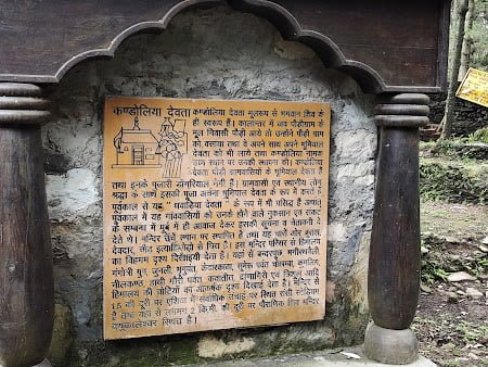
Kandoliya Temple
The Kandoliya Temple is a small shrine located in the Pithoragarh district of Uttarakhand, in the Indian Himalayas. The temple is dedicated to the goddess Durga, and it is an important site for the local people, who believe that the goddess protects them from harm. The temple is located in the Kandoliya village, which is a short distance from Kandoliya Bugyal, a beautiful meadow in the region.
The Kandoliya Temple is a popular destination for hikers and pilgrims, and it offers stunning views of the surrounding landscape. The temple is a great place to learn more about the local culture and religion, and it is an important part of the region’s history.
Mythology of Kandoliya Temple
The Kandoliya Temple is a small shrine located in the Pithoragarh district of Uttarakhand, in the Indian Himalayas. The temple is dedicated to the goddess Durga, who is a popular deity in Hindu mythology. According to Hindu tradition, Durga is the mother of the universe, and she is revered as the protector and defender of the weak.
There are many myths and stories associated with the goddess Durga. One popular story tells of how Durga was created by the combined energies of all the gods and goddesses in order to defeat the demon Mahishasura. According to the story, Mahishasura was a powerful demon who had been granted a boon by the gods that made him invulnerable to attack. In order to defeat him, the gods and goddesses combined their energies to create Durga, who was able to defeat Mahishasura in battle and restore peace to the world.
The Kandoliya Temple is an important site for Hindus, who believe that the goddess Durga protects them from harm and brings them prosperity and good fortune. The temple is a popular destination for hikers and pilgrims, and it offers a glimpse into the rich mythology and culture of the region.
How to reach Kandoliya Temple
The temple is a short distance from Kandoliya Bugyal, a beautiful meadow in the region.
To reach the Kandoliya Temple, you will first need to reach the town of Pithoragarh, which is the nearest major town to the temple. Pithoragarh is well-connected to other major cities in India by road and rail. The nearest airport to Pithoragarh is the Jolly Grant Airport in Dehradun, which is about 270 kilometers (167 miles) away.
From Pithoragarh, you can take a taxi or a bus to Kandoliya village. The journey from Pithoragarh to Kandoliya village takes about 3-4 hours by road, and the route passes through beautiful forests and mountains.
The Best Hikes in Kandoliya Bugyal
The meadow is surrounded by dense forests and snow-capped peaks, and it offers a number of excellent hiking trails for all levels of ability. Here are a few of the best hikes in Kandoliya Bugyal:
- Mini Switzerland: Located a short distance from Kandoliya Bugyal, Mini Switzerland is a small meadow that offers stunning views of the surrounding landscape. The meadow is surrounded by dense forests and snow-capped peaks, and it is a great place to relax and take in the natural beauty of the region. The hike to Mini Switzerland is relatively easy, and it is suitable for hikers of all levels of ability.
- Panchachuli Peaks: The Panchachuli Peaks are a group of five snow-capped peaks located in the Pithoragarh district of Uttarakhand. The peaks are popular with hikers and mountaineers, and they offer a challenging and rewarding trekking experience. The Panchachuli Peaks are located a short distance from Kandoliya Bugyal, and they are a great destination for those looking to explore the region further. The hike to the Panchachuli Peaks is moderate to difficult, and it is suitable for experienced hikers.
- Ralam Glacier: The Ralam Glacier is a beautiful and relatively unknown glacier located in the Pithoragarh district of Uttarakhand. The glacier is surrounded by dense forests and snow-capped peaks, and it is a great place to explore on foot. The Ralam Glacier is located a short distance from Kandoliya Bugyal, and it is a great destination for those looking to experience the beauty of the region. The hike to the Ralam Glacier is moderate in difficulty, and it is suitable for hikers with some experience.
Khaliya Top Bugyal
Khaliya Top Bugyal is a beautiful meadow located in the Pithoragarh district of Uttarakhand, in the Indian Himalayas. The meadow is surrounded by dense forests and snow-capped peaks, and it is a popular destination for hikers and trekkers.
Khaliya Top Bugyal is located at an altitude of about 4,000 meters (13,123 feet), and it offers stunning views of the surrounding landscape. The meadow is a great place to relax and take in the natural beauty of the region, and it is also a great base for exploring the surrounding area.
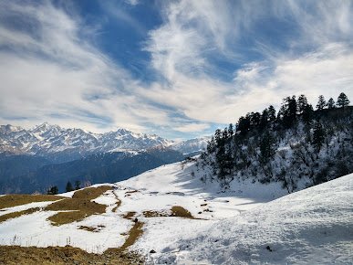
The best time to visit Khaliya Top Bugyal is from May to October, when the weather is mild and the meadow is in full bloom. The winter months can be very cold and snowy, and the meadow is often covered in deep snow, making it difficult to access.
I hope this information gives you an idea of what to expect at Khaliya Top Bugyal.
Suggested Detailed Khaliya Top Bugyal Trekking Itinerary
Here is a suggested itinerary for a trek to Khaliya Top Bugyal:
Day 1: Arrive in Pithoragarh and transfer to your hotel. Spend the day relaxing and acclimatizing to the high altitude.
Day 2: Drive to Khaliya Top Bugyal. The drive takes about 4-5 hours and passes through beautiful forests and mountains. Upon arrival, check into your campsite and spend the rest of the day exploring the meadow and taking in the stunning views.
Day 3: Hike to Mini Switzerland, a small meadow located a short distance from Khaliya Top Bugyal. The hike is relatively easy and takes about 4-5 hours round trip. Return to your campsite in the evening.
Day 4: Hike to the Panchachuli Peaks, a group of five snow-capped peaks located a short distance from Khaliya Top Bugyal. The hike is moderate to difficult, and it takes about 6-7 hours round trip. Return to your campsite in the evening.
Day 5: Hike to the Ralam Glacier, a beautiful and relatively unknown glacier located a short distance from Khaliya Top Bugyal. The hike is moderate in difficulty, and it takes about 5-6 hours round trip. Return to your campsite in the evening.
Day 6: Spend the day relaxing at the campsite and taking in the beautiful surroundings.
Day 7: Drive back to Pithoragarh and transfer to your hotel.
Day 8: Depart Pithoragarh.
This itinerary is just a suggestion, and you can adjust it to suit your own interests and schedule. The best time to visit Khaliya Top Bugyal is from May to October, when the weather is mild and the meadow is in full bloom. The winter months can be very cold and snowy, and the meadow is often covered in deep snow, making it difficult to access.
A Beginner’s Guide to Trekking in Khaliya Top Bugyal:
The meadow is surrounded by dense forests and snow-capped peaks, and it is a popular destination for hikers and trekkers. If you’re planning a trek to Khaliya Top Bugyal, here are a few tips to help you prepare:
- Best time to go: The best time to visit Khaliya Top Bugyal is from May to October, when the weather is mild and the meadow is in full bloom. The winter months can be very cold and snowy, and the meadow is often covered in deep snow, making it difficult to access.
- What to pack: When trekking in Khaliya Top Bugyal, it’s important to pack the right gear to keep you warm and comfortable. Some essential items to bring include a good quality waterproof jacket and trousers, a warm hat and gloves, thermal layers, and a good quality sleeping bag. You’ll also need to bring plenty of water, as the high altitude can be dehydrating.
- How to prepare for the high altitude: Khaliya Top Bugyal is located at an altitude of about 4,000 meters (13,123 feet), and the high altitude can cause some people to experience symptoms of altitude sickness. To prepare for the high altitude, it’s important to spend a few days acclimatizing before starting your trek, and to drink plenty of water to stay hydrated. If you start to experience symptoms such as headache, nausea, or dizziness, it’s important to take it easy and rest until you feel better.
I hope these tips help you prepare for your trek to Khaliya Top Bugyal.
Exploring the Culture and History of Khaliya Top Bugyal:
If you’re interested in exploring the culture and history of Khaliya Top Bugyal, here are a few things you might find interesting:
- The local community: Khaliya Top Bugyal is located in a remote area, and the local community is made up of small villages that rely on agriculture and tourism for their livelihoods. Many of the villagers are of Tibetan descent, and they follow a mix of Hinduism and Tibetan Buddhism. The villagers are very friendly and welcoming, and they are an important part of the local culture and history.
- Cultural sites: There are a number of cultural and religious sites located in the area around Khaliya Top Bugyal, including the Kandoliya Temple, which is an ancient temple dedicated to the Hindu god Shiva. The temple is located a short distance from the meadow, and it is a popular place for pilgrims to visit. There are also several small monasteries located in the area, which are an important part of the local culture and history.
- The meadow itself: Khaliya Top Bugyal is an important part of the local culture and history, and it has long been used as a summer grazing ground by the local villagers. The meadow is surrounded by dense forests and snow-capped peaks, and it is a popular destination for hikers and trekkers. The meadow is a great place to relax and take in the natural beauty of the region, and it is also a great base for exploring the surrounding area.
I hope this information gives you an idea of what to expect when exploring the culture and history of Khaliya Top Bugyal.
Off the Beaten Path: Hidden Gems in Khaliya Top Bugyal:
The meadow is surrounded by dense forests and snow-capped peaks, and it is a popular destination for hikers and trekkers. If you’re looking to get off the beaten path and explore some of the lesser-known or less-visited areas of Khaliya Top Bugyal, here are a few ideas:
- Hidden trails: There are a number of hidden trails and paths in the area around Khaliya Top Bugyal that are worth exploring. These trails are often less crowded than the more popular trails, and they offer a chance to escape the crowds and experience the natural beauty of the region in a more peaceful and serene setting. Some of the best trails to explore include the Ralam Glacier Trail, which leads to a beautiful and relatively unknown glacier, and the Panchachuli Peaks Trail, which leads to a group of five snow-capped peaks.
- Scenic viewpoints: There are several scenic viewpoints located in the area around Khaliya Top Bugyal that offer stunning views of the surrounding landscape. These viewpoints are often less crowded than the more popular viewpoints, and they offer a chance to take in the natural beauty of the region in a more peaceful and serene setting. Some of the best viewpoints to visit include Mini Switzerland, a small meadow located a short distance from Khaliya Top Bugyal, and the Kandoliya Temple, which offers panoramic views of the surrounding landscape.
- Cultural sites: There are several cultural and religious sites located in the area around Khaliya Top Bugyal that are worth exploring. These sites are often less visited than the more popular sites, and they offer a chance to learn more about the local culture and history. Some of the best cultural sites to visit include the Kandoliya Temple, which is an ancient temple dedicated to the Hindu god Shiva, and the Panchachuli Peaks, which are a group of five snow-capped peaks that are considered sacred by the local community.
I hope these suggestions give you some ideas for exploring the lesser-known or less-visited areas of Khaliya Top Bugyal
The Best Hikes in Khaliya Top Bugyal:
If you’re looking for the best hikes in Khaliya Top Bugyal, here are a few suggestions:
- Ralam Glacier Trail: The Ralam Glacier Trail is a moderate to difficult hike that leads to a beautiful and relatively unknown glacier. The trail is approximately 12 kilometers (7.5 miles) long, and it takes about 6-7 hours to complete. Along the way, you’ll pass through dense forests, meadows, and streams, and you’ll have the opportunity to see a variety of wildlife, including Himalayan tahr, blue sheep, and Himalayan black bear. The final ascent to the glacier is steep and challenging, but the views from the top are well worth the effort.
- Panchachuli Peaks Trail: The Panchachuli Peaks Trail is a moderate to difficult hike that leads to a group of five snow-capped peaks that are considered sacred by the local community. The trail is approximately 25 kilometers (15.5 miles) long, and it takes about 3-4 days to complete. Along the way, you’ll pass through dense forests, meadows, and streams, and you’ll have the opportunity to see a variety of wildlife, including Himalayan tahr, blue sheep, and Himalayan black bear. The final ascent to the peaks is steep and challenging, but the views from the top are breathtaking.
- Kandoliya Temple Trail: The Kandoliya Temple Trail is a moderate hike that leads to an ancient temple dedicated to the Hindu god Shiva. The trail is approximately 3 kilometers (1.9 miles) long, and it takes about 1-2 hours to complete. Along the way, you’ll pass through dense forests and meadows, and you’ll have the opportunity to see a variety of wildlife, including Himalayan tahr, blue sheep, and Himalayan black bear. The final ascent to the temple is steep, but the views from the top are well worth the effort.
How difficult is khaliya top trek?
The difficulty of the Khaliya Top Trek will depend on a number of factors, including your level of fitness, your experience with hiking and trekking, and the specific route you take. Generally speaking, the Khaliya Top Trek is considered a moderate to difficult trek, and it is recommended for experienced hikers and trekkers who are in good physical condition.
The Khaliya Top Trek typically takes 3-4 days to complete, and it involves a combination of hiking and camping. The trail takes you through dense forests, meadows, and streams, and it is a great opportunity to see a variety of wildlife, including Himalayan tahr, blue sheep, and Himalayan black bear. The final ascent to Khaliya Top Bugyal is steep and challenging, but the views from the top are well worth the effort.
If you are planning to do the Khaliya Top Trek, it is important to be in good physical condition and to be properly prepared. You should be able to hike for several hours at a time and be able to carry a backpack with all of your gear and supplies. It is also important to be prepared for the high altitude and to acclimatize properly to avoid altitude sickness.
Stay in Khaliya Top
If you are planning to visit Khaliya Top Bugyal, there are several options for staying in the area. Some of the most popular options include:
- Camping: One of the most popular ways to stay in Khaliya Top Bugyal is to pitch a tent and camp out under the stars. There are several designated camping areas in the meadow, and you can either bring your own tent or rent one from a local vendor. Camping is a great way to experience the natural beauty of Khaliya Top Bugyal and to get closer to nature.
- Homestays: Another option for staying in Khaliya Top Bugyal is to stay in a homestay. Homestays are local homes that have been converted into guesthouses, and they offer a more authentic and immersive experience of the local culture. Many homestays in Khaliya Top Bugyal offer simple, clean, and comfortable accommodation, and some even provide meals and other amenities.
- Hotels: If you prefer a more traditional form of accommodation, you can also stay in a hotel in the nearby town of Pithoragarh. Pithoragarh is located about 45 kilometers (28 miles) from Khaliya Top Bugyal, and it has a number of hotels, guesthouses, and resorts to choose from. Staying in a hotel in Pithoragarh is a good option if you are looking for more luxurious or modern amenities.
How to reach Khaliya Top
If you are planning to visit Khaliya Top Bugyal, there are several ways to reach the meadow, depending on your starting location. Here are a few options for getting to Khaliya Top Bugyal:
- By Road: Khaliya Top Bugyal is located in the Pithoragarh district of Uttarakhand, in the Indian Himalayas. If you are coming by road, you can take a bus or a taxi from the nearby town of Pithoragarh to the trailhead at Dhakuri. From Dhakuri, it is a 5-6 hour hike to Khaliya Top Bugyal. Alternatively, you can hire a taxi or a jeep to take you directly to the meadow, although this option is more expensive and may not be available during the monsoon season.
- By Rail: The nearest railway station to Khaliya Top Bugyal is located in Pithoragarh, which is about 45 kilometers (28 miles) from the meadow. From Pithoragarh, you can take a bus or a taxi to the trailhead at Dhakuri. Alternatively, you can hire a taxi or a jeep to take you directly to the meadow.
- By Air: The nearest airport to Khaliya Top Bugyal is located in Pantnagar, which is about 300 kilometers (186 miles) from the meadow. From Pantnagar, you can take a bus or a taxi to Pithoragarh, and then follow the directions above to reach Khaliya Top Bugyal.
Madhmaheshwar Bugyal
Madhmaheshwar Bugyal is a beautiful alpine meadow located in the Indian state of Uttarakhand, in the Himalayan mountain range. The meadow is situated at an altitude of 3,280 meters (10,760 feet) above sea level, and it is surrounded by dense forests and snow-capped peaks. Madhmaheshwar Bugyal is a popular destination for hikers and trekkers, who come to enjoy the stunning views, the crisp mountain air, and the peaceful atmosphere of the meadow.
Madhmaheshwar Bugyal is located in the Kumaon region of Uttarakhand, and it can be reached by a moderate to difficult trek from the nearby town of Lohajung. The trek to Madhmaheshwar Bugyal typically takes 4-5 days to complete, and it involves a combination of hiking and camping. The trail takes you through dense forests, meadows, and streams, and it is a great opportunity to see a variety of wildlife, including Himalayan tahr, blue sheep, and Himalayan black bear.
If you are planning to visit Madhmaheshwar Bugyal, it is important to be in good physical condition and to be properly prepared. You should be able to hike for several hours at a time and be able to carry a backpack with all of your gear and supplies. It is also important to be prepared for the high altitude and to acclimatize properly to avoid altitude sickness.
A Beginner’s Guide to Trekking in Madhmaheshwar Bugyal:
here is some information that could be included in a beginner’s guide to trekking in Madhmaheshwar Bugyal:
- Best Time to Go: The best time to visit Madhmaheshwar Bugyal depends on your preferences and the activities you want to do. If you want to experience the meadow in all its glory, the best time to go is from May to June, when the weather is mild and the flowers are in bloom. If you want to see the meadow covered in snow, the best time to go is from December to February, when the temperature drops below freezing and the meadow is blanketed in snow.
- What to Pack: When packing for a trek to Madhmaheshwar Bugyal, it is important to bring the right gear and supplies to keep you comfortable and safe. Some of the items you should consider packing include:
- Warm and waterproof clothing: The weather in Madhmaheshwar Bugyal can be unpredictable, so it is important to bring clothes that will keep you warm and dry in case of rain or snow.
- Hiking boots: A good pair of hiking boots is essential for a comfortable and safe trek. Make sure to break them in before your trip to avoid blisters.
- Sleeping bag: If you are planning to camp on the trek, you will need a sleeping bag to stay warm at night.
- Water bottles: It is important to stay hydrated during the trek, so make sure to bring enough water bottles to last you the whole trip.
- First aid kit: A basic first aid kit with band-aids, painkillers, and other essential items can come in handy in case of minor injuries or illnesses.
- How to Prepare for the High Altitude: Madhmaheshwar Bugyal is located at an altitude of 3,280 meters (10,760 feet) above sea level, which can be challenging for some people. To prepare for the high altitude, it is important to do some acclimatization hikes before your trip to get your body used to the thin air. It is also important to drink plenty of water and eat a high-carb diet to help your body adjust to the altitude. If you experience any symptoms of altitude sickness, such as headache, dizziness, or shortness of breath, it is important to descend to a lower altitude and seek medical attention if necessary.
Exploring the Culture and History of Madhmaheshwar Bugyal:
The culture and history of Madhmaheshwar Bugyal:
- Importance of the Meadow to the Local Community: Madhmaheshwar Bugyal is an important resource for the local community, who rely on the meadow for pastureland and a source of water. The meadow is also a popular destination for tourists, who come to enjoy the beauty of the place and to participate in activities such as trekking, camping, and picnicking.
- Cultural Sites: Madhmaheshwar Bugyal is home to several cultural sites, including temples, shrines, and ruins. Some of the notable cultural sites in the area include the Madhmaheshwar Temple, dedicated to the Hindu god Shiva, and the ruins of the Rajgari Fort, which was built by the Chand dynasty in the 16th century.
- Local Festivals: Madhmaheshwar Bugyal is home to several local festivals, which are an important part of the region’s culture. Some of the notable festivals in the area include the Madhmaheshwar Fair, which is held every year in the month of August, and the Kandoliya Temple Fair, which is held every year in the month of October.
Off the Beaten Path: Hidden Gems in Madhmaheshwar Bugyal:
Here are a few ideas for hidden gems in Madhmaheshwar Bugyal that could be included in a post about off the beaten path destinations:
- Hidden Trails: Madhmaheshwar Bugyal is home to several hidden trails that offer breathtaking views and a chance to experience the beauty of the place in a more secluded setting. Some of the hidden trails in the area include the Rajgari Fort Trail, which takes you through the ruins of the 16th century fort, and the Madhmaheshwar Temple Trail, which takes you to the Madhmaheshwar Temple, located at the highest point in the meadow.
- Scenic Viewpoints: Madhmaheshwar Bugyal is home to several scenic viewpoints that offer panoramic views of the surrounding landscape. Some of the notable viewpoints in the area include the Kandoliya Temple Viewpoint, which offers a sweeping view of the valley below, and the Madhmaheshwar Temple Viewpoint, which offers a panoramic view of the meadow and the Himalayan peaks beyond.
- Cultural Sites: Madhmaheshwar Bugyal is home to several cultural sites that are often overlooked by travelers, including the Kandoliya Temple, dedicated to the Hindu god Shiva, and the ruins of the Rajgari Fort, which was built by the Chand dynasty in the 16th century.
The Best Hikes in Madhmaheshwar Bugyal:
Few ideas for the best hikes in Madhmaheshwar Bugyal:
- Madhmaheshwar Temple Trek: This trek takes you to the Madhmaheshwar Temple, located at the highest point in the meadow. The trek is relatively easy and takes about 3-4 hours to complete. Along the way, you’ll get to enjoy breathtaking views of the surrounding landscape and the Himalayan peaks beyond.
- Kandoliya Temple Trek: This trek takes you to the Kandoliya Temple, located at the edge of the meadow. The trek is of moderate difficulty and takes about 6-7 hours to complete. Along the way, you’ll get to see a variety of landscapes, including forests, meadows, and streams.
- Rajgari Fort Trek: This trek takes you through the ruins of the Rajgari Fort, which was built by the Chand dynasty in the 16th century. The trek is of moderate difficulty and takes about 6-7 hours to complete. Along the way, you’ll get to see a variety of landscapes, including forests, meadows, and streams, as well as the ruins of the fort itself.
Suggested detailed Madhmaheshwar Bugyal Trekking Itinerary
Day 1: Arrive in Madhmaheshwar and acclimatize to the high altitude. Spend the day exploring the local area and getting to know the culture and history of the place.
Day 2: Start the Madhmaheshwar Temple Trek. The trek is relatively easy and takes about 3-4 hours to complete. Along the way, you’ll get to enjoy breathtaking views of the surrounding landscape and the Himalayan peaks beyond.
Day 3: Spend the day exploring the local area and visiting cultural sites such as the Madhmaheshwar Temple and the Rajgari Fort.
Day 4: Start the Kandoliya Temple Trek. The trek is of moderate difficulty and takes about 6-7 hours to complete. Along the way, you’ll get to see a variety of landscapes, including forests, meadows, and streams.
Day 5: Spend the day exploring the local area and visiting cultural sites such as the Kandoliya Temple.
Day 6: Start the Rajgari Fort Trek. The trek is of moderate difficulty and takes about 6-7 hours to complete. Along the way, you’ll get to see a variety of landscapes, including forests, meadows, and streams, as well as the ruins of the fort itself.
Day 7: Depart from Madhmaheshwar.
I hope this itinerary gives you an idea of what to expect during a trek to Madhmaheshwar Bugyal.
How difficult is Madmaheshwar Trek?
The difficulty of the Madhmaheshwar Trek depends on your level of fitness and experience as a trekker. Generally, the trek is considered to be of moderate difficulty, as it involves a moderate level of physical exertion and some steep inclines. However, the trek is not overly strenuous and can be completed by most people in good physical condition.
To prepare for the trek, it is important to get in good physical shape by exercising regularly and building up your stamina. This can be achieved through activities such as running, cycling, or swimming. It is also important to properly acclimatize to the high altitude, as the trek takes place at an elevation of over 3,000 meters above sea level. To acclimatize, it is recommended to spend a few days in Madhmaheshwar before starting the trek, and to drink plenty of fluids to stay hydrated.
How to reach Madhyamaheshwar Bugyal
To reach Madhmaheshwar Bugyal, you will need to first reach the village of Madhmaheshwar, which is located in the Chamoli district of Uttarakhand, India. From Madhmaheshwar, the bugyal (meadow) is located at a distance of about 5 kilometers. You can hire a taxi or take a local bus to reach the bugyal from Madhmaheshwar.
If you are coming from a distant location, you can reach Madhmaheshwar by air, train, or bus, as described in my previous message. The nearest airport is Jolly Grant Airport in Dehradun, and the nearest railway station is Rishikesh. From there, you can hire a taxi or take a bus to Madhmaheshwar.
Hotel in Madhmaheshwar Bugyal?
There are several hotels and guest houses in Madhmaheshwar that offer accommodation to travelers. Here are a few options:
- Hotel Madhmaheshwar: This is a budget hotel located in the heart of Madhmaheshwar. It offers simple, clean rooms with basic amenities such as hot water, TV, and Wi-Fi.
- Hotel Ganga View: This hotel is located in a peaceful and scenic location, with views of the Ganges River. It offers comfortable rooms with private bathrooms and balconies.
- Hotel Giriraj: This hotel is located in the center of Madhmaheshwar, close to the bus stand. It offers clean and comfortable rooms with private bathrooms and hot water.
- Hotel Gauri Shankar: This hotel is located in a quiet and peaceful location, with views of the surrounding mountains. It offers clean and comfortable rooms with private bathrooms and hot water.
Neel Ganga Bugyal
Neel Ganga Bugyal is a beautiful meadow located in the Chamoli district of Uttarakhand, India. It is situated at an altitude of around 3,000 meters above sea level, and is surrounded by towering peaks of the Himalayas. Neel Ganga Bugyal is known for its picturesque landscape, dotted with colorful wildflowers and alpine trees. The meadow is a popular destination for hikers and trekkers, who come to explore its natural beauty and peaceful surroundings.
To reach Neel Ganga Bugyal, you will need to first reach the village of Joshimath, which is located about 15 kilometers from the bugyal. From Joshimath, you can hire a taxi or take a local bus to reach Neel Ganga Bugyal. If you are coming from a distant location, you can reach Joshimath by air, train, or bus. The nearest airport is Jolly Grant Airport in Dehradun, and the nearest railway station is Rishikesh. From there, you can hire a taxi or take a bus to Joshimath.
A Beginner’s Guide to Trekking in Neel Ganga Bugyal:
- Best time to visit: The best time to visit Neel Ganga Bugyal is during the summer months, from May to June, when the weather is pleasant and the meadow is covered in wildflowers. The winter months, from November to February, can also be a good time to visit, but the temperature can drop to subzero levels, so you will need to be well prepared with warm clothing and gear.
- How to reach: To reach Neel Ganga Bugyal, you will need to first reach the village of Joshimath, which is located about 15 kilometers from the bugyal. From Joshimath, you can hire a taxi or take a local bus to reach Neel Ganga Bugyal. If you are coming from a distant location, you can reach Joshimath by air, train, or bus. The nearest airport is Jolly Grant Airport in Dehradun, and the nearest railway station is Rishikesh. From there, you can hire a taxi or take a bus to Joshimath.
- Trekking route: The trek to Neel Ganga Bugyal begins at the village of Joshimath, and takes you through a mix of forests, meadows, and streams. The total distance of the trek is about 12 kilometers, and it takes about 5-6 hours to complete. The trek can be divided into two days, with an overnight stay at a campsite or homestay in the village of Deval. The trail is marked and well-maintained, and is suitable for beginners.
- What to pack: When planning a trek to Neel Ganga Bugyal, it is important to pack the right gear and equipment. Some essential items to pack include a good pair of trekking shoes, warm clothing, a waterproof jacket, a hat, sunscreen, a flashlight, a first-aid kit, and enough food and water for the journey. You should also carry a map and a compass, and let someone know your itinerary before you start the trek.
Exploring the Culture and History of Neel Ganga Bugyal
- Local culture: Neel Ganga Bugyal is located in the Chamoli district of Uttarakhand, a region known for its rich cultural heritage and traditional way of life. The local community is primarily made up of farmers, shepherds, and artisans, who are known for their hardworking and hospitable nature. The region is also home to many temples and shrines, which are an important part of the local culture.
- History: Neel Ganga Bugyal is said to have been discovered by a group of shepherds who were grazing their goats on the meadow. The name “Neel Ganga” comes from the blue-colored stream that flows through the meadow, which is believed to have healing properties. According to local legend, the stream is home to a guardian spirit who protects the area from evil forces.
- Temples and cultural sites: There are several temples and cultural sites that can be found in and around Neel Ganga Bugyal. Some of the notable ones include the Madhmaheshwar Temple, which is located at the base of the meadow, and the Neelkanth Temple, which is located at the summit. Both of these temples are dedicated to the Hindu god Shiva, and are popular destinations for pilgrims. Other cultural sites in the area include the Nanda Devi Temple, the Joshimath Temple, and the Tapovan Temple.
Off the Beaten Path: Hidden Gems in Neel Ganga Bugyal:
- Hidden trails: Neel Ganga Bugyal is surrounded by a network of trails that lead to various scenic viewpoints and cultural sites. Some of these trails are well-known and well-trodden, while others are more obscure and less traveled. These hidden trails offer a chance to explore the meadow away from the crowds and discover hidden vistas that are not visible from the main trails.
- Scenic viewpoints: There are several viewpoints in Neel Ganga Bugyal that offer breathtaking panoramic views of the surrounding mountains and valleys. Some of these viewpoints are well-known, while others are more secluded and less visited. Exploring these hidden viewpoints can be a rewarding experience, as they offer a chance to appreciate the beauty of the meadow in a more intimate setting.
- Cultural sites: In addition to the main temples and shrines in Neel Ganga Bugyal, there are also a number of lesser-known cultural sites that are worth exploring. These could include ancient ruins, abandoned temples, or hidden shrines that are not well-known to tourists. These sites offer a glimpse into the rich cultural heritage of the region and can be a rewarding experience for those who are interested in history and culture.
I hope these ideas give you some inspiration for your blog post on Neel Ganga Bugyal.
Places to visit in Neel Ganga Bugyal
Here are some of the places that you might want to visit during your trip to Neel Ganga Bugyal:
- Binsar Mahadev Temple: This temple is located in the heart of Neel Ganga Bugyal and is dedicated to Lord Shiva. It is a popular pilgrimage site and is surrounded by a number of smaller shrines and temples.
- Neel Ganga River: The Neel Ganga River flows through the meadow and is a great place to relax and take in the surroundings. You can take a dip in the cool waters or simply sit by the river and enjoy the peaceful atmosphere.
- Scenic viewpoints: There are several viewpoints in Neel Ganga Bugyal that offer breathtaking panoramic views of the surrounding mountains and valleys. Some of the most popular viewpoints include Jhandi Dhar, Rangar Koti, and Sari Koti.
- Cultural sites: In addition to the main temples and shrines in Neel Ganga Bugyal, there are also a number of cultural sites that are worth exploring. These could include ancient ruins, abandoned temples, or hidden shrines that are not well-known to tourists.
- Adventure activities: Neel Ganga Bugyal is a great place for adventure enthusiasts, with activities such as trekking, rock climbing, and paragliding on offer. If you are looking for an adrenaline rush, you can try your hand at one of these activities.
How to reach Neel Ganga Bugyal
- From Dehradun: If you are starting from Dehradun, you can take a bus or hire a private taxi to reach the town of Srinagar in Pauri Garhwal district. From Srinagar, you can take another bus or taxi to the village of Mundoli, which is the starting point of the Neel Ganga Bugyal trek. The journey from Dehradun to Mundoli takes around 6-7 hours by road.
- From Rishikesh: If you are starting from Rishikesh, you can take a bus or hire a private taxi to reach the town of Lansdowne in Pauri Garhwal district. From Lansdowne, you can take another bus or taxi to the village of Mundoli. The journey from Rishikesh to Mundoli takes around 5-6 hours by road.
- From Haridwar: If you are starting from Haridwar, you can take a bus or hire a private taxi to reach the town of Srinagar in Pauri Garhwal district. From Srinagar, you can take another bus or taxi to the village of Mundoli. The journey from Haridwar to Mundoli takes around 6-7 hours by road.
Stay in Neel Ganga Bugyal
There are several options for accommodation in and around Neel Ganga Bugyal, including guest houses, hotels, and homestays. Here are a few options to consider:
- Neelganga Homestay: This homestay is located in the village of Mundoli, which is the starting point of the Neel Ganga Bugyal trek. The homestay offers comfortable rooms with attached bathrooms and panoramic views of the surrounding mountains.
- Hotel Panch Kedar: This hotel is located in the town of Srinagar, which is a convenient base for exploring the Neel Ganga Bugyal region. The hotel offers clean and comfortable rooms with attached bathrooms and modern amenities.
- Devnandan Guest House: This guest house is located in the town of Lansdowne, which is a popular hill station in the region. The guest house offers basic rooms with attached bathrooms and a homely atmosphere.
Suggested Detailed Neel Ganga Bugyal Trekking Itinerary
Here is a suggested 7-day trekking itinerary for Neel Ganga Bugyal:
Day 1: Drive from Dehradun to Mundoli (6-7 hours). Overnight stay in Mundoli.
Day 2: Trek from Mundoli to Neel Ganga Bugyal (5-6 hours). Overnight stay in a tent at Neel Ganga Bugyal.
Day 3: Acclimatization and exploration day at Neel Ganga Bugyal. Overnight stay in a tent.
Day 4: Trek from Neel Ganga Bugyal to Bedini Bugyal (6-7 hours). Overnight stay in a tent at Bedini Bugyal.
Day 5: Trek from Bedini Bugyal to Mundoli (5-6 hours). Overnight stay in Mundoli.
Day 6: Drive from Mundoli to Dehradun (6-7 hours). Overnight stay in Dehradun.
Day 7: Departure from Dehradun.
Please note that this is just a suggested itinerary and can be customized based on your preferences and fitness level. The trek can also be extended to include visits to other nearby attractions such as Khaliya Top, Dayara Bugyal, and Ransi Stadium.
Raithal Bugyal
Raithal Bugyal is a high-altitude meadow located in the Chamoli district of Uttarakhand. It is situated at an altitude of 3,800 meters above sea level and is surrounded by the snow-capped peaks of the Garhwal Himalayas. The meadow is covered with grass and wildflowers during the summer months and offers breathtaking views of the surrounding mountains. Raithal Bugyal is a popular destination for trekkers and nature lovers, and is also home to several species of Himalayan wildlife such as blue sheep and pheasants. The best time to visit Raithal Bugyal is from May to October, when the weather is pleasant and the meadow is at its most beautiful.
Raithal Bugyal Weather
The weather in Raithal Bugyal can vary greatly depending on the time of year you visit. In the summer months (June to September), the weather is generally pleasant with temperatures ranging from 20°C to 30°C. However, it can get quite humid during this time.
In the winter months (December to February), the weather is much colder, with temperatures dropping to as low as -10°C at night. There is also a chance of snowfall during this time, so it’s important to dress warmly and bring appropriate clothing and gear.
The monsoon season (July to September) brings heavy rainfall to the region, which can make the trails slippery and difficult to navigate. If you plan on trekking during this time, it’s important to be prepared for wet conditions and bring appropriate rain gear.
Overall, the best time to visit Raithal Bugyal is during the summer months, when the weather is pleasant and the trails are dry. However, if you enjoy skiing or snow sports, the winter months can also be a great time to visit.
How difficult is Raithal Bugyal Trek?
The difficulty level of the Raithal Bugyal trek may vary depending on a number of factors, including your physical fitness level, acclimatization to high altitudes, and the route you choose to take. In general, the Raithal Bugyal trek is considered a moderate to challenging trek, with a total distance of approximately 21 kilometers and an elevation gain of around 2,000 meters. The trek involves a mix of easy to moderate terrain, including some steep ascents and descents on rocky trails. You may also encounter some snow on the route, depending on the time of year you go. It is important to be in good physical shape and properly acclimatized to high altitudes before attempting the Raithal Bugyal trek.
Suggested detailed Raithal Bugyal Trekking Itinerary:
Day 1: Arrive in Rishikesh and transfer to the base camp at Sankri. Acclimatize and spend the night in a guesthouse.
Day 2: Trek from Sankri to Taluka. The trail passes through dense forests and offers views of the Himalayan ranges. Overnight stay in a tent.
Day 3: Trek from Taluka to Seema. The trail becomes steeper as you ascend to Seema, a small village in the heart of the Kumaon Himalayas. Overnight stay in a tent.
Day 4: Trek from Seema to Raithal. The trail takes you through the picturesque Raithal meadow, offering breathtaking views of the surrounding peaks. Overnight stay in a tent.
Day 5: Explore Raithal and its surroundings. Visit the local villages and temples, and enjoy the peaceful surroundings. Overnight stay in a tent.
Day 6: Trek from Raithal to Seema. The descent to Seema offers more opportunities to admire the breathtaking views. Overnight stay in a tent.
Day 7: Trek from Seema to Taluka and transfer to Sankri. Overnight stay in a guesthouse.
Day 8: Drive back to Rishikesh and transfer to the airport for your onward journey.
This itinerary can be customized based on your preferences and the number of days you have available for the trek. It is always best to allow for some flexibility in case of unforeseen circumstances, such as weather delays or illness.
Places to visit in Raithal Bugyal
Here are a few places to visit in Raithal Bugyal:
- Khaliya Top: A scenic viewpoint that offers panoramic views of the Himalayas, including Nanda Devi and Trishul peaks.
- Raithal Temple: A centuries-old temple that is believed to be one of the oldest in the region.
- Raithal Museum: A museum that displays artifacts and items of historical and cultural significance, including ancient scriptures and weapons.
- Raithal Craft Village: A village where traditional crafts are practiced, including wood carving, pottery, and weaving.
- Raithal Meadows: A series of lush green meadows that offer breathtaking views of the surrounding mountains and forests.
- Raithal Waterfall: A beautiful waterfall that cascades down a rocky cliff, creating a serene and peaceful atmosphere
Stay in Raithal Bugyal
To stay in Raithal Bugyal, you can consider booking a room at a local guest house or homestay. These accommodations are often run by the local community and offer a more authentic and immersive experience. You can also consider camping in the area, although it’s important to obtain the necessary permits and follow proper camping etiquette. If you prefer a more luxurious option, there are also a few resorts and hotels in the nearby town of Rishikesh that offer easy access to Raithal Bugyal. It’s a good idea to book your accommodation in advance, especially during peak season.
How to reach Raithal Bugyal
- Reach Rishikesh: Rishikesh is the nearest major city to Raithal Bugyal and is well-connected by road, rail, and air. You can take a bus or train from Delhi to Rishikesh, or you can fly to Jolly Grant Airport in Dehradun and then take a taxi to Rishikesh.
- From Rishikesh, take a taxi to Srinagar, which is the starting point of the trek. The drive from Rishikesh to Srinagar takes around 6-7 hours.
- From Srinagar, the trek to Raithal Bugyal begins. The trek takes around 3-4 days and covers a distance of around 50 kilometers.
- Alternatively, you can also take a taxi from Srinagar to Raithal Bugyal, which is a shorter but steeper route. This route takes around 2-3 hours by car.
I hope this helps!
Tapovan Bugyal
Tapovan Bugyal is a large, open meadow located in the Garhwal region of the Indian state of Uttarakhand. It is situated at an altitude of 4,320 meters (14,173 feet) above sea level, and is known for its natural beauty and peaceful surroundings. The meadow is surrounded by snow-capped mountains, and is covered with a carpet of wildflowers during the summer months. It is also home to a variety of alpine flora and fauna, including many species of rare plants and animals.
The Tapovan Temple is located near the meadow, and is a popular destination for pilgrims who come to the area to seek blessings from the deities. The temple is dedicated to Lord Shiva, and is believed to be one of the holiest places in the region.
The area around Tapovan Bugyal is also a popular destination for trekkers, who come to explore the beautiful mountain trails that lead through the meadow and surrounding forests. The meadow can be reached by trekking from the nearby town of Joshimath, which is located about 45 kilometers away. The trek to Tapovan Bugyal takes about three days, and is considered moderate in difficulty.
Overall, Tapovan Bugyal is a beautiful and peaceful place, perfect for those who want to escape the hustle and bustle of city life and immerse themselves in nature. It is a great place to relax, meditate, and connect with the natural world.
A Beginner’s Guide to Trekking in Tapovan Bugyal:
Planning a trek to Tapovan Bugyal can be an exciting and rewarding experience, but it’s important to be prepared for the challenges of high altitude and varied terrain. Here are some tips for beginners planning a trek to Tapovan Bugyal:
- Best time to go: Tapovan Bugyal is best visited during the summer months of May to September, when the weather is warm and dry. However, the meadow can also be visited in the winter, when it is covered in a blanket of snow. Keep in mind that the weather can be unpredictable at high altitude, so it’s important to be prepared for all types of conditions.
- What to pack: Make sure to bring plenty of layers, as the weather can change quickly. Waterproof jackets and trousers are also essential, as well as good-quality hiking boots and socks. Other important items to pack include a first aid kit, sunscreen, a hat, and sunglasses. It’s also a good idea to bring some energy bars or other snacks to keep your energy levels up.
- How to prepare for high altitude: Tapovan Bugyal is located at an altitude of around 4,320 meters (14,173 feet), so it’s important to take the necessary precautions to avoid altitude sickness. To prepare for the high altitude, make sure to drink plenty of water, eat a healthy diet, and get plenty of rest in the days leading up to the trek. It’s also a good idea to acclimatize slowly, by spending a few days at lower altitudes before attempting the trek. If you experience any symptoms of altitude sickness, such as headache, dizziness, or nausea, it’s important to descend to a lower altitude as soon as possible.
Exploring the Culture and History of Tapovan Bugyal:
Tapovan Bugyal is a beautiful high-altitude meadow located in the Chamoli district of Uttarakhand, India. The meadow is known for its natural beauty and is a popular destination for trekkers and nature lovers. But Tapovan Bugyal is more than just a natural wonder – it is also rich in culture and history, with a deep connection to the local community and the surrounding region.
The meadow is considered a sacred place by the local community, and is home to several temples and other cultural sites. One of the most notable is the Tapovan Temple, which is dedicated to Lord Shiva and is located at the base of the Nar Parbat mountain. The temple is believed to be over 3,000 years old and is an important site of pilgrimage for Hindus.
In addition to the Tapovan Temple, there are several other cultural sites in the area, including the Bhavishya Badri Temple, which is located at the end of the trek to Tapovan Bugyal. The temple is believed to be the site where the Pandava Brothers, the heroes of the Hindu epic Mahabharata, meditated during their exile. The Pandava Brothers are also said to have built a bridge to the heaven from Tapovan Bugyal, which is now known as the “Nar-Narayan Parbat.”
Aside from its cultural significance, Tapovan Bugyal is also an important source of livelihood for the local community. The meadow is used for pasture, and the local community relies on the natural resources of the area for their livelihood. The meadow is also a popular destination for tourism, which brings in much-needed income to the region.
In summary, Tapovan Bugyal is a place that is rich in culture and history, and is an important part of the local community and the surrounding region. Exploring the meadow allows visitors to learn more about the area’s culture and history, and to appreciate the deep connection that the local community has with the natural world.
Off the Beaten Path: Hidden Gems in Tapovan Bugyal:
While Tapovan Bugyal is a popular destination for trekkers and nature lovers, there are still plenty of hidden gems and off-the-beaten-path attractions to discover. Here are a few lesser-known or less-visited areas of Tapovan Bugyal that you might want to explore:
- Hidden trails: While the main trail to Tapovan Bugyal is well-known and well-marked, there are also many hidden trails that lead to secluded viewpoints and scenic areas. Some of these trails are well-known to the local community, while others are more difficult to find. If you’re up for a bit of exploration, consider venturing off the main trail and see what you can discover.
- Scenic viewpoints: There are many scenic viewpoints in Tapovan Bugyal that offer breathtaking views of the surrounding mountains and valleys. Some of these viewpoints are well-known, while others are more difficult to find. To discover some of the lesser-known viewpoints, consider hiring a local guide or asking the locals for recommendations.
- Cultural sites: In addition to the well-known temples and cultural sites in Tapovan Bugyal, there are also many lesser-known sites that are worth exploring. These might include small shrines, ancient ruins, or other landmarks that are off the beaten path. To discover these hidden gems, consider asking the locals for recommendations or hiring a guide who is familiar with the area.
Overall, Tapovan Bugyal is a place that is full of hidden gems and off-the-beaten-path attractions, and exploring these areas can add an extra layer of adventure to your trip. So don’t be afraid to venture off the main trail and see what you can discover!
Tapovan Temple
The Tapovan Temple is a Hindu temple located in the Chamoli district of Uttarakhand, India. The temple is located at the base of the Nar Parbat mountain and is dedicated to Lord Shiva. The temple is believed to be over 3,000 years old and is an important site of pilgrimage for Hindus. It is also located near the high-altitude meadow of Tapovan Bugyal, which is considered a sacred place by the local community. The temple is an important part of the local culture and history, and is a popular destination for tourists and pilgrims alike.
Nar Parbat Mountain
Nar Parbat is a mountain located in the Chamoli district of Uttarakhand, India. The mountain is situated near the high-altitude meadow of Tapovan Bugyal and is considered a sacred place by the local community. The mountain is home to the Tapovan Temple, which is dedicated to Lord Shiva and is believed to be over 3,000 years old. The mountain is also associated with the legend of the Pandava Brothers, who are said to have meditated at the base of the mountain during their exile. Nar Parbat is a popular destination for trekkers and hikers, and offers breathtaking views of the surrounding mountains and valleys.
The Best Hikes in Tapovan Bugyal:
The meadow is a popular destination for trekkers and hikers, and offers a variety of trails for visitors to explore. Here are some of the best hikes in Tapovan Bugyal, including information on their difficulty, length, and the type of scenery you can expect to see along the way:
- Tapovan Bugyal Trek: The main trek to Tapovan Bugyal is a moderate to challenging hike that takes around 3-4 days to complete. The trek begins at Joshimath and passes through several villages and forests before reaching the meadow. Along the way, you’ll have the opportunity to see a variety of landscapes, including forests, waterfalls, and snow-capped peaks. The trek culminates at the Bhavishya Badri Temple, which is located at the end of the trail.
- Day Hikes in Tapovan Bugyal: If you don’t have time for a multi-day trek, there are also several shorter day hikes that you can take from Tapovan Bugyal. Some of the best options include the hike to the Chandrashila Peak, which offers stunning views of the surrounding mountains, and the hike to the Rishi Ganga waterfalls, which is a beautiful and serene spot.
- Off-the-beaten-path trails: If you’re looking for a more adventurous hike, consider venturing off the main trails and exploring some of the lesser-known trails in Tapovan Bugyal. These trails may be more challenging and less crowded, but they offer the opportunity to see some truly breathtaking landscapes and to get off the beaten path.
Overall, Tapovan Bugyal offers a variety of hikes for visitors to choose from, ranging from easy day hikes to challenging multi-day treks. No matter which trail you choose, you’re sure to be rewarded with stunning views and a sense of adventure.
A Beginner’s Guide to Trekking in Tapovan Bugyal:
Planning a trek to Tapovan Bugyal can be an exciting and rewarding experience, but it’s important to be prepared for the challenges of high altitude and varied terrain. Here are some tips for beginners planning a trek to Tapovan Bugyal:
- Best time to go: Tapovan Bugyal is best visited during the summer months of May to September, when the weather is warm and dry. However, the meadow can also be visited in the winter, when it is covered in a blanket of snow. Keep in mind that the weather can be unpredictable at high altitude, so it’s important to be prepared for all types of conditions.
- What to pack: Make sure to bring plenty of layers, as the weather can change quickly. Waterproof jackets and trousers are also essential, as well as good-quality hiking boots and socks. Other important items to pack include a first aid kit, sunscreen, a hat, and sunglasses. It’s also a good idea to bring some energy bars or other snacks to keep your energy levels up.
- How to prepare for high altitude: Tapovan Bugyal is located at an altitude of around 4,320 meters (14,173 feet), so it’s important to take the necessary precautions to avoid altitude sickness. To prepare for the high altitude, make sure to drink plenty of water, eat a healthy diet, and get plenty of rest in the days leading up to the trek. It’s also a good idea to acclimatize slowly, by spending a few days at lower altitudes before attempting the trek. If you experience any symptoms of altitude sickness, such as headache, dizziness, or nausea, it’s important to descend to a lower altitude as soon as possible.
Exploring the Culture and History of Tapovan Bugyal:
The meadow is considered a sacred place by the local community, and is home to several temples and other cultural sites. One of the most notable is the Tapovan Temple, which is dedicated to Lord Shiva and is located at the base of the Nar Parbat mountain. The temple is believed to be over 3,000 years old and is an important site of pilgrimage for Hindus.
In addition to the Tapovan Temple, there are several other cultural sites in the area, including the Bhavishya Badri Temple, which is located at the end of the trek to Tapovan Bugyal. The temple is believed to be the site where the Pandava Brothers, the heroes of the Hindu epic Mahabharata, meditated during their exile. The Pandava Brothers are also said to have built a bridge to the heaven from Tapovan Bugyal, which is now known as the “Nar-Narayan Parbat.”
Aside from its cultural significance, Tapovan Bugyal is also an important source of livelihood for the local community. The meadow is used for pasture, and the local community relies on the natural resources of the area for their livelihood. The meadow is also a popular destination for tourism, which brings in much-needed income to the region.
In summary, Tapovan Bugyal is a place that is rich in culture and history, and is an important part of the local community and the surrounding region. Exploring the meadow allows visitors to learn more about the area’s culture and history, and to appreciate the deep connection that the local community has with the natural world.
Off the Beaten Path: Hidden Gems in Tapovan Bugyal:
Here are a few lesser-known or less-visited areas of Tapovan Bugyal that you might want to explore:
- Hidden trails: While the main trail to Tapovan Bugyal is well-known and well-marked, there are also many hidden trails that lead to secluded viewpoints and scenic areas. Some of these trails are well-known to the local community, while others are more difficult to find. If you’re up for a bit of exploration, consider venturing off the main trail and see what you can discover.
- Scenic viewpoints: There are many scenic viewpoints in Tapovan Bugyal that offer breathtaking views of the surrounding mountains and valleys. Some of these viewpoints are well-known, while others are more difficult to find. To discover some of the lesser-known viewpoints, consider hiring a local guide or asking the locals for recommendations.
- Cultural sites: In addition to the well-known temples and cultural sites in Tapovan Bugyal, there are also many lesser-known sites that are worth exploring. These might include small shrines, ancient ruins, or other landmarks that are off the beaten path. To discover these hidden gems, consider asking the locals for recommendations or hiring a guide who is familiar with the area.
Overall, Tapovan Bugyal is a place that is full of hidden gems and off-the-beaten-path attractions, and exploring these areas can add an extra layer of adventure to your trip.
Tapovan Temple
The Tapovan Temple is a Hindu temple located in the Chamoli district of Uttarakhand, India. The temple is located at the base of the Nar Parbat mountain and is dedicated to Lord Shiva. The temple is believed to be over 3,000 years old and is an important site of pilgrimage for Hindus. It is also located near the high-altitude meadow of Tapovan Bugyal, which is considered a sacred place by the local community. The temple is an important part of the local culture and history, and is a popular destination for tourists and pilgrims alike.
Nar Parbat Mountain
Nar Parbat is a mountain located in the Chamoli district of Uttarakhand, India. The mountain is situated near the high-altitude meadow of Tapovan Bugyal and is considered a sacred place by the local community. The mountain is home to the Tapovan Temple, which is dedicated to Lord Shiva and is believed to be over 3,000 years old. The mountain is also associated with the legend of the Pandava Brothers, who are said to have meditated at the base of the mountain during their exile. Nar Parbat is a popular destination for trekkers and hikers, and offers breathtaking views of the surrounding mountains and valleys.
The Best Hikes in Tapovan Bugyal:
Here are some of the best hikes in Tapovan Bugyal, including information on their difficulty, length, and the type of scenery you can expect to see along the way:
- Tapovan Bugyal Trek: The main trek to Tapovan Bugyal is a moderate to challenging hike that takes around 3-4 days to complete. The trek begins at Joshimath and passes through several villages and forests before reaching the meadow. Along the way, you’ll have the opportunity to see a variety of landscapes, including forests, waterfalls, and snow-capped peaks. The trek culminates at the Bhavishya Badri Temple, which is located at the end of the trail.
- Day Hikes in Tapovan Bugyal: If you don’t have time for a multi-day trek, there are also several shorter day hikes that you can take from Tapovan Bugyal. Some of the best options include the hike to the Chandrashila Peak, which offers stunning views of the surrounding mountains, and the hike to the Rishi Ganga waterfalls, which is a beautiful and serene spot.
- Off-the-beaten-path trails: If you’re looking for a more adventurous hike, consider venturing off the main trails and exploring some of the lesser-known trails in Tapovan Bugyal. These trails may be more challenging and less crowded, but they offer the opportunity to see some truly breathtaking landscapes and to get off the beaten path.
Overall, Tapovan Bugyal offers a variety of hikes for visitors to choose from, ranging from easy day hikes to challenging multi-day treks
Stay in Tapovan Bugyal
There are several accommodation options available in Tapovan Bugyal, ranging from hotels and guesthouses to campsites. Here are a few options to consider:
- Hotels and guesthouses: There are several hotels and guesthouses located in the villages near Tapovan Bugyal, which offer basic facilities and comfortable accommodation. These options are a good choice for travelers who prefer a more comfortable stay.
- Campsites: There are several campsites located in Tapovan Bugyal, which offer a more rustic and adventurous way to stay. These campsites usually provide tents or huts for travelers to stay in, and may also offer basic facilities such as toilets and dining areas.
- Homestays: Another option to consider is staying in a homestay, which allows you to stay with a local family and experience the culture and traditions of the region firsthand. Homestays are a good choice for travelers who want to immerse themselves in the local way of life.
Overall, the type of accommodation you choose will depend on your preferences and budget. If you’re looking for a more comfortable stay, you might prefer a hotel or guesthouse. If you’re looking for a more rustic and adventurous experience, a campsite or homestay might be a better choice.
How to Reach Tapovan Bugyal
There are several ways to reach Tapovan Bugyal, depending on your starting location. Here is an overview of the main options:
- By air: The nearest airport to Tapovan Bugyal is Jolly Grant Airport in Dehradun, which is located around 280 kilometers (174 miles) away. From there, you can hire a taxi or take a bus to reach Tapovan Bugyal.
- By train: The nearest railway station to Tapovan Bugyal is Rishikesh, which is located around 265 kilometers (165 miles) away. From there, you can hire a taxi or take a bus to reach Tapovan Bugyal.
- By bus: There are several direct buses that run from Dehradun and Rishikesh to Tapovan Bugyal. Alternatively, you can catch a bus to Joshimath and then hire a taxi or take a local bus to reach Tapovan Bugyal.
- By car: If you’re driving to Tapovan Bugyal, the main route to follow is from Dehradun to Rishikesh and then on to Joshimath. From Joshimath, you can follow the road to Tapovan Bugyal. The journey by car takes around 8-9 hours, depending on traffic and road conditions.
Overall, the best way to reach Tapovan Bugyal will depend on your starting location and the mode of transportation you prefer.
Best time to visit Tapovan Bugyal
The best time to visit Tapovan Bugyal depends on what you hope to do while you’re there and your personal preferences. Here are a few factors to consider:
- Weather: Tapovan Bugyal has a cold, alpine climate, with temperatures ranging from around 10°C (50°F) in the summer to below freezing in the winter. The summer months of May to September are generally the best time to visit, as the weather is warm and dry. However, if you enjoy the cold and snow, you might prefer to visit in the winter, when the meadow is covered in a blanket of snow.
- Trekking conditions: If you’re planning to trek to Tapovan Bugyal, the summer months of May to September are generally the best time to go, as the trails are dry and the weather is warm. However, if you’re an experienced trekker and don’t mind the cold, you might be able to complete the trek in the winter months as well. Keep in mind that the weather can be unpredictable at high altitude, so it’s important to be prepared for all types of conditions.
- Cultural events: Tapovan Bugyal is home to several cultural events and festivals throughout the year. If you’re interested in experiencing local culture, you might want to visit during one of these events. Some of the notable events include the Shivaratri festival in February, the Holi festival in March, and the Navaratri festival in September.
Panwali Kantha Bugyal
Panwali Kantha is a high-altitude meadow located in the Chamoli district of Uttarakhand, India. The meadow is situated at an elevation of around 3,200 meters (10,500 feet) and is known for its natural beauty and serene surroundings. Panwali Kantha is a popular destination for trekkers and nature lovers, and is known for its stunning views of the Himalayan mountains and the surrounding forests and valleys. The meadow is also home to a variety of flora and fauna, including a variety of alpine plants and wildlife such as Himalayan musk deer and blue sheep.
A Beginner’s Guide to Trekking in Panwali Kantha
Here is a beginner’s guide to trekking in Panwali Kantha, including information on the best time to go, what to pack, and how to prepare for the high altitude:
- Best time to go: The best time to trek to Panwali Kantha depends on your personal preferences and the activities you hope to do while you’re there. The summer months of May to September are generally the best time to visit, as the weather is warm and dry and the trails are in good condition. However, if you enjoy the cold and snow, you might prefer to visit in the winter, when the meadow is covered in a blanket of snow.
- What to pack: When trekking to Panwali Kantha, it’s important to pack appropriately for the high altitude and the cold weather. Some essential items to include in your pack are warm clothing, a waterproof jacket and pants, a hat and gloves, a good pair of hiking boots, a first aid kit, and plenty of water and snacks. You should also bring a map and a compass, and make sure you have a way to charge your phone or other electronic devices.
- How to prepare for the high altitude: Trekking to Panwali Kantha involves hiking at high altitude, which can be challenging for some people. To prepare for the high altitude, it’s important to acclimatize gradually and to listen to your body. Drink plenty of water, take it easy on the first few days of the trek, and if you start to feel dizzy or short of breath, stop and rest. It’s also a good idea to consult with your doctor before embarking on the trek, especially if you have any pre-existing medical conditions.
Exploring the Culture and History of Panwali Kantha:
overview of the culture and history of Panwali Kantha:
- Local culture: The local culture of Panwali Kantha is shaped by the Hindu religion and the traditions of the Garhwali people. The region is home to several ancient temples, including the Badrinath Temple, which is one of the holiest shrines in Hinduism. The people of Panwali Kantha are known for their warm hospitality and traditional way of life, which is centered around agriculture and livestock farming.
- History: The history of Panwali Kantha is closely tied to the history of the Garhwal region. The region has a long and rich history, with evidence of human habitation dating back to the Neolithic period. The region has been ruled by various empires and dynasties over the centuries, including the Mughals, the Gurkhas, and the British. The region was also a key center of the Indian independence movement, and many freedom fighters hailed from the Garhwal region.
- The importance of the meadow: Panwali Kantha is an important meadow for the local community, as it provides a vital source of pasture for livestock. The meadow is also a key source of tourism for the region, as it attracts a large number of trekkers and nature lovers each year. The meadow is protected by the government and is an important part of the region’s cultural and natural heritage.
The Best Hikes in Panwali Kantha:
Panwali Kantha is a beautiful high-altitude meadow located in the Chamoli district of Uttarakhand, India. The meadow offers a variety of trails for hikers of all levels, ranging from easy day hikes to challenging multi-day treks. Here are some of the best hikes in Panwali Kantha, including information on their difficulty, length, and the type of scenery you can expect to see along the way:
- Panwali Kantha Trek: The Panwali Kantha Trek is a moderate to difficult trek that takes you through some of the most beautiful landscapes in the region. The trek starts from Joshimath and takes you through dense forests, past waterfalls and streams, and over high mountain passes. The trek is around 8-9 days long, depending on your route and pace, and takes you to an elevation of around 3,200 meters (10,500 feet). Along the way, you’ll have the opportunity to see stunning views of the Himalayan mountains, as well as a variety of flora and fauna.
- Kuari Pass Trek: The Kuari Pass Trek is a moderate to difficult trek that takes you through the beautiful Kuari Pass, which is located at an elevation of around 3,665 meters (12,000 feet). The trek starts from Joshimath and takes you through dense forests, past waterfalls and streams, and over high mountain passes. The trek is around 5-6 days long, depending on your route and pace, and takes you to an elevation of around 3,665 meters (12,000 feet). Along the way, you’ll have the opportunity to see stunning views of the Himalayan mountains, as well as a variety of flora and fauna.
- Satopanth Lake Trek: The Satopanth Lake Trek is a moderate to difficult trek that takes you to the beautiful Satopanth Lake, which is located at an elevation of around 4,700 meters (15,400 feet). The trek starts from Joshimath and takes you through dense forests, past waterfalls and streams, and over high mountain passes. The trek is around 5-6 days long, depending on your route and pace, and takes you to an elevation of around 4,700 meters
Photographing Panwali Kantha: Tips and Techniques
Here are some tips and techniques for photographing Panwali Kantha:
- Best time of day to shoot: The best time of day to photograph Panwali Kantha depends on the type of shots you’re looking to capture. For landscape shots, the golden hour (just before sunrise and just after sunset) is generally the best time to shoot, as the light is soft and warm and the colors are more vibrant. For shots of the mountain peaks, early morning is often the best time to shoot, as the peaks are often shrouded in clouds later in the day.
- Best lenses to use: The best lenses to use for photographing Panwali Kantha depend on the type of shots you’re looking to capture. For landscape shots, a wide-angle lens is generally the best choice, as it allows you to capture the grandeur of the scenery. For shots of the mountain peaks, a telephoto lens is often the best choice, as it allows you to zoom in and capture the details of the peaks.
- Dealing with challenging lighting conditions: Photographing Panwali Kantha can be challenging due to the high altitude and the changing weather conditions. To deal with challenging lighting conditions, it’s important to be prepared and to have the right gear. Bring a tripod to help steady your camera in low light conditions, and consider bringing a polarizing filter to help reduce reflections and boost the colors in your shots. It’s also a good idea to be flexible and to be willing to adjust your shooting plans based on the weather and light conditions.
Suggested Detailed Panwali Kantha Trekking Itinerary:
Here is a suggested detailed itinerary for a trek to Panwali Kantha, including information on the best routes to take, where to stay, and what to see along the way:
Day 1: Arrive in Joshimath and acclimatize. Joshimath is a good base for trekking in the region and has a variety of accommodation options to choose from. Spend the day exploring the town and getting prepared for the trek.
Day 2: Drive from Joshimath to the starting point of the trek at Govindghat. The drive takes around 3 hours and offers stunning views of the Himalayan mountains. From Govindghat, start the trek to Ghangaria, the main base camp for the Panwali Kantha Trek. The trek takes around 6-7 hours and takes you through dense forests and past waterfalls and streams. Overnight in Ghangaria.
Day 3: Trek from Ghangaria to Panwali Kantha. The trek takes around 5-6 hours and takes you to an elevation of around 3,200 meters (10,500 feet). Along the way, you’ll have the opportunity to see stunning views of the Himalayan mountains, as well as a variety of flora and fauna. Overnight in Panwali Kantha.
Day 4: Spend the day exploring Panwali Kantha and the surrounding area. There are several trails you can follow, ranging from easy day hikes to challenging multi-day treks. Take your time and enjoy the stunning scenery. Overnight in Panwali Kantha.
Day 5: Trek from Panwali Kantha back to Ghangaria. The trek takes around 5-6 hours and takes you back down to an elevation of around 2,800 meters (9,200 feet). Overnight in Ghangaria.
Day 6: Trek from Ghangaria back to Govindghat. The trek takes around 6-7 hours and takes you back down to an elevation of around 2,000 meters (6,600 feet). From Govindghat, drive back to Joshimath. Overnight in Joshimath.
Day 7: Depart from Joshimath.
How Difficult is the Panwali Kantha Trek?
The Panwali Kantha Trek is a moderate to difficult trek that takes you through some of the most beautiful landscapes in the Chamoli district of Uttarakhand, India. The trek takes you to an elevation of around 3,200 meters (10,500 feet) and involves a significant amount of elevation gain. Here is an overview of the difficulty level of the Panwali Kantha Trek, including information on the terrain, elevation gain, and other factors that may impact the difficulty of the trek:
- Terrain: The Panwali Kantha Trek takes you through a variety of terrain, including forests, streams, and mountain passes. The trek involves a significant amount of ascent and descent, with some steep and rocky sections. The trek can be challenging due to the high altitude and the changing weather conditions, which can be unpredictable.
- Elevation gain: The Panwali Kantha Trek involves a significant amount of elevation gain, with the highest point of the trek reaching an elevation of around 3,200 meters (10,500 feet). The trek involves a total ascent of around 1,200 meters (3,900 feet) over a distance of around 22 kilometers (14 miles).
- Other factors: The difficulty of the Panwali Kantha Trek is also influenced by other factors, such as your fitness level, your acclimatization, and your experience with trekking. The trek can be challenging for those who are not in good physical condition or who are not well acclimatized to high altitudes. It is important to be properly prepared and to take the necessary precautions to ensure a safe and enjoyable trek.
Places to Visit in Panwali Kantha
The meadow offers a variety of attractions and things to see for those who are interested in exploring the local culture and history. Here are some of the top places to visit in Panwali Kantha:
- Panwali Kantha Temple: The Panwali Kantha Temple is a popular attraction in the area, and is believed to be over 1,000 years old. The temple is dedicated to Lord Shiva and is located in a beautiful and peaceful setting. The temple is a popular spot for pilgrims and offers stunning views of the surrounding mountains.
- Scenic viewpoints: Panwali Kantha is home to a variety of scenic viewpoints that offer stunning views of the Himalayan mountains and the surrounding landscape. Some of the top viewpoints include the Kuari Pass, the Satopanth Lake, and the Nilkanth Peak.
- Cultural sites: Panwali Kantha is rich in cultural and historical sites, including temples, monasteries, and ancient ruins. Some of the top cultural sites in the area include the Auli Temple, the Tapovan Temple, and the Vyas Temple.
- Other landmarks: Panwali Kantha is also home to a variety of other landmarks, including forests, streams, and waterfalls. Some of the top landmarks in the area include the Joshimath Temple, the Nanda Devi National Park, and the Hemkund Sahib Gurudwara.
Stay in Panwali Kantha:
Here is an overview of the various accommodation options available in Panwali Kantha:
- Hotels: There are a few hotels and guesthouses located in the Panwali Kantha area that offer basic amenities such as beds, blankets, and electricity. These hotels are generally basic and may not have running water or other modern amenities.
- Campsites: There are several campsites located in the Panwali Kantha area that offer a more rustic and outdoor-oriented experience. These campsites generally provide basic facilities such as toilets and water, but you will need to bring your own tent and camping gear.
- Homestays: There are a few homestays located in the Panwali Kantha area that offer a more local and authentic experience. These homestays are generally run by local families and offer basic amenities such as beds and blankets.
It’s important to note that the accommodation options in Panwali Kantha are limited and may not be suitable for everyone. If you are planning to stay in the area, it’s a good idea to book your accommodation in advance and to be prepared for a more basic and rustic experience.
Places to visit in Panwali Kantha in brief
- The Auli Temple: The Auli Temple is a popular attraction located in the Auli ski resort, which is located in the Chamoli district. The temple is dedicated to Lord Shiva and is believed to be over 1,000 years old. The temple is surrounded by beautiful forests and offers stunning views of the surrounding mountains.
- The Tapovan Temple: The Tapovan Temple is a popular attraction located in the Tapovan area, which is located in the Chamoli district. The temple is dedicated to Lord Shiva and is believed to be over 1,000 years old. The temple is surrounded by beautiful forests and offers stunning views of the surrounding mountains.
- The Vyas Temple: The Vyas Temple is a popular attraction located in the Vyas area, which is located in the Chamoli district. The temple is dedicated to the sage Vyasa and is believed to be over 1,000 years old. The temple is surrounded by beautiful forests and offers stunning views of the surrounding mountains.
- The Joshimath Temple: The Joshimath Temple is a popular attraction located in the Joshimath area, which is located in the Chamoli district. The temple is dedicated to Lord Shiva and is believed to be over 1,000 years old. The temple is surrounded by beautiful forests and offers stunning views of the surrounding mountains.
- The Nanda Devi National Park: The Nanda Devi National Park is a popular attraction located in the Chamoli district. The park is home to a variety of wildlife, including Himalayan black bears, snow leopards, and musk deer. The park is also home to a number of beautiful lakes and streams, and offers stunning views of the surrounding mountains.
- The Hemkund Sahib Gurudwara: The Hemkund Sahib Gurudwara is a popular attraction located in the Chamoli district. The gurudwara is a holy site for Sikhs and is located in a beautiful and peaceful setting. The gurudwara is surrounded by beautiful forests and offers stunning views of the surrounding mountains.
- The Kuari Pass: The Kuari Pass is a popular attraction located in the Chamoli district. The pass is a high-altitude mountain pass that offers stunning views of the Himalayan mountains and the surrounding landscape. The pass is a popular spot for trekkers and hikers and can be accessed from the Auli ski resort.
- The Satopanth Lake: The Satopanth Lake is a beautiful and serene lake located in the Chamoli district. The lake is located at an elevation of around 4,500 meters (14,800 feet) and is surrounded by stunning mountain views. The lake is a popular spot for trekkers and hikers and is considered to be one of the holiest lakes in the area.
- The Nilkanth Peak: The Nilkanth Peak is a popular attraction located in the Chamoli district. The peak is a high-altitude mountain that offers stunning views of the Himalayan mountains and the surrounding landscape. The peak is a popular spot for trekkers and hikers and can be accessed from the Auli ski resort.
Chaainsheel Bugyal
Chaainsheel Bugyal is a high-altitude meadow located in the Chamoli district of Uttarakhand, India. The meadow is situated at an elevation of around 3,500 meters (11,500 feet) and is surrounded by beautiful forests and mountain views. Chaainsheel Bugyal is a popular destination for trekkers and hikers, and offers a variety of attractions and things to see, including cultural sites, scenic viewpoints, and other landmarks. Some of the top attractions and things to see in Chaainsheel Bugyal include the Kuari Pass, the Satopanth Lake, and the Nilkanth Peak. The meadow is also home to a variety of accommodation options, including hotels, guesthouses, and campsites.
A Beginner’s Guide to Trekking in Chaainsheel Bugyal:
- Best time to go: The best time to go trekking in Chaainsheel Bugyal depends on your personal preferences and the type of experience you are looking for. The meadow is open to visitors from May to October, and during this time, the weather is generally pleasant and suitable for trekking. The months of June to September are considered the best time to go trekking in Chaainsheel Bugyal, as the weather is generally dry and sunny, and the meadow is in full bloom. However, if you prefer cooler temperatures and fewer crowds, you may want to consider visiting Chaainsheel Bugyal in the months of May or October.
What to pack:
- When trekking in Chaainsheel Bugyal, it is important to pack the right gear and equipment to ensure a safe and comfortable journey. Some essential items to pack include:
- Comfortable, sturdy shoes or hiking boots
- Warm, layered clothing, including a jacket and gloves
- Rain gear (such as a waterproof jacket and pants)
- A hat and sunglasses to protect against the sun and wind
- Sunscreen and lip balm
- A first aid kit
- A flashlight or headlamp
- A water bottle and snacks
- How to prepare for the high altitude: Chaainsheel Bugyal is located at a high altitude of around 3,500 meters (11,500 feet), and it is important to prepare for the effects of high altitude on your body. To prepare for the high altitude, it is recommended to:
- Gradually acclimatize to the altitude by spending a few days in a lower-altitude area before starting your trek
- Stay well hydrated by drinking plenty of water
- Avoid alcohol and smoking
- Eat a high-carbohydrate diet
- Take it easy and listen to your body
- If you start to feel the effects of high altitude sickness, such as headache, dizziness, or shortness of breath, it is important to stop and rest until you feel better. It is also a good idea to inform your guide or a member of your group if you are feeling unwell.
Exploring the Culture and History of Chaainsheel Bugyal:
Chaainsheel Bugyal is located in the Chamoli district of Uttarakhand, India, and has a rich cultural history that dates back centuries. The meadow is considered to be an important spiritual and cultural site for the local community, and is home to a variety of temples and cultural landmarks. Here is some more information on the culture and history of Chaainsheel Bugyal:
- Importance to the local community: Chaainsheel Bugyal is an important site for the local community, and is considered to be a sacred and holy place. The meadow is believed to be a place of spiritual and physical rejuvenation, and is visited by thousands of people each year. The meadow is also an important source of income for the local community, as it is a popular destination for trekkers and hikers.
- Temples and cultural sites: Chaainsheel Bugyal is home to a variety of temples and cultural sites that are worth exploring. Some of the top temples and cultural sites to visit in Chaainsheel Bugyal include:
- The Auli Temple: The Auli Temple is a popular temple located in the Chamoli district. The temple is dedicated to the Hindu god Lord Vishnu and is an important spiritual site for the local community.
- The Tapovan Temple: The Tapovan Temple is a popular temple located in the Chamoli district. The temple is dedicated to the Hindu god Lord Shiva and is an important spiritual site for the local community.
- The Vyas Temple: The Vyas Temple is a popular temple located in the Chamoli district. The temple is dedicated to the Hindu sage Vyasa and is an important spiritual site for the local community.
- The Joshimath Temple: The Joshimath Temple is a popular temple located in the Chamoli district. The temple is dedicated to the Hindu god Lord Vishnu and is an important spiritual site for the local community.
- The Nanda Devi National Park: The Nanda Devi National Park is a popular attraction located in the Chamoli district. The park is home to a variety of flora and fauna, and is a great place to explore the natural beauty of the region.
- The Hemkund Sahib Gurudwara: The Hemkund Sahib Gurudwara is a popular gurudwara (Sikh place of worship) located in the Chamoli district. The gurudwara is an important spiritual site for the Sikh community and is a popular destination for pilgrims.
The Best Hikes in Chaainsheel Bugyal
Here are some of the best hikes in Chaainsheel Bugyal:
- Chaainsheel Bugyal Trek: The Chaainsheel Bugyal Trek is a popular trek that takes you through the beautiful meadow of Chaainsheel Bugyal. The trek is considered to be of moderate difficulty and is suitable for experienced trekkers. The trek is around 15 kilometers (9 miles) in length and takes around 3-4 days to complete. Along the way, you will get to see stunning views of the Himalayan mountain range and the surrounding landscape.
- Kuari Pass Trek: The Kuari Pass Trek is a popular trek that takes you through the beautiful mountain passes of Kuari. The trek is considered to be of moderate difficulty and is suitable for experienced trekkers. The trek is around 50 kilometers (31 miles) in length and takes around 7-8 days to complete. Along the way, you will get to see stunning views of the Himalayan mountain range and the surrounding landscape.
- Satopanth Lake Trek: The Satopanth Lake Trek is a popular trek that takes you to the beautiful Satopanth Lake. The trek is considered to be of moderate difficulty and is suitable for experienced trekkers. The trek is around 50 kilometers (31 miles) in length and takes around 7-8 days to complete. Along the way, you will get to see stunning views of the Himalayan mountain range and the surrounding landscape.
- Nilkanth Peak Trek: The Nilkanth Peak Trek is a popular trek that takes you to the summit of the Nilkanth Peak. The trek is considered to be of
Photographing Chaainsheel Bugyal: Tips and Techniques:
Here are some tips and techniques for photographing Chaainsheel Bugyal:
- Best time of day to shoot: The best time of day to shoot in Chaainsheel Bugyal depends on the type of photograph you are trying to capture. If you want to capture the beautiful landscapes and mountain ranges of Chaainsheel Bugyal, the early morning and late afternoon are generally the best times to shoot, as the light is softer and more diffuse during these times. If you want to capture the vibrant colors of the meadow, the mid-morning and early afternoon are generally the best times to shoot, as the light is brighter and more direct during these times.
- Best lenses to use: The best lenses to use in Chaainsheel Bugyal depend on the type of photograph you are trying to capture. If you want to capture the beautiful landscapes and mountain ranges of Chaainsheel Bugyal, a wide-angle lens is generally the best choice, as it allows you to capture a wide field of view and includes more of the surrounding landscape. If you want to capture close-up details of the meadow, such as flowers or plants, a telephoto lens is generally the best choice, as it allows you to zoom in and capture more detailed shots.
- How to deal with challenging lighting conditions: Photographing in Chaainsheel Bugyal can sometimes be challenging due to the high altitude and the harsh lighting conditions. To deal with these challenges, it is important to:
- Use a polarizing filter to reduce reflections and enhance the colors of the landscape
- Use a graduated filter to balance the exposure between the sky and the foreground
- Use a high dynamic range (HDR) technique to capture a wider range of exposures in a single shot
- Use a tripod to steady your camera and avoid camera shake
- Use a fast shutter speed to freeze action and avoid blur
- Use a low ISO setting to reduce noise and maintain image quality
How Difficult is the Chaainsheel Bugyal Trek?
The difficulty level of the Chaainsheel Bugyal trek:
- Terrain: The Chaainsheel Bugyal trek takes you through a variety of terrain, including meadows, forests, and mountain passes. The terrain is generally well-marked and easy to follow, but there are some steep and rocky sections that can be challenging to navigate.
- Elevation gain: The Chaainsheel Bugyal trek takes you to an elevation of around 3,658 meters (12,000 feet) above sea level. The trek involves a significant elevation gain, with some steep ascents and descents. The high altitude can be challenging for some people, and it is important to acclimatize to the altitude before embarking on the trek.
- Other factors: Other factors that can impact the difficulty of the Chaainsheel Bugyal trek include the weather, the duration of the trek, and the physical fitness of the trekker. The weather in Chaainsheel Bugyal can be unpredictable, with temperatures ranging from hot and sunny to cold and snowy. The trek can also be physically demanding, and it is important to be in good physical shape and have good endurance before embarking on the trek.
Overall, the Chaainsheel Bugyal trek is considered to be of moderate difficulty, and is suitable for experienced trekkers. It is important to properly prepare for the trek, including packing the necessary gear and supplies, and to be mindful of the challenges and risks that may be encountered on the trek.
Suggested Detailed Chaainsheel Bugyal Trekking Itinerary:
suggested detailed Chaainsheel Bugyal trekking itinerary:
Day 1: Arrive in Joshimath and acclimatize to the altitude
- Arrive in Joshimath, a small town located in the Chamoli district of Uttarakhand, India.
- Check into your accommodation and take some time to rest and acclimatize to the altitude.
- Explore the town of Joshimath and visit some of the local temples, such as the Joshimath Temple, the Nanda Devi National Park, and the Hemkund Sahib Gurudwara.
Day 2: Trek from Joshimath to Chaainsheel Bugyal (5-6 hours)
- Start your trek from Joshimath and follow the well-marked trail to Chaainsheel Bugyal.
- The trek is around 15 kilometers (9 miles) in length and takes around 5-6 hours to complete.
- The trail takes you through beautiful meadows, forests, and mountain passes, and offers stunning views of the Himalayan mountain range and the surrounding landscape.
Day 3: Explore Chaainsheel Bugyal and visit the Auli Temple, the Tapovan Temple, and the Vyas Temple
- Spend the day exploring the beautiful meadow of Chaainsheel Bugyal and visiting the local temples.
- The Auli Temple is a small temple located in the center of the meadow, and is dedicated to the Hindu deity Lord Shiva.
- The Tapovan Temple is a small temple located at the edge of the meadow, and is dedicated to the Hindu deity Lord Vishnu.
- The Vyas Temple is a small temple located at the edge of the meadow, and is dedicated to the Hindu sage Vyasa.
Day 4: Trek from Chaainsheel Bugyal to Joshimath (5-6 hours)
- Start your trek back to Joshimath and follow the same route that you took on the way up.
- The trek is around 15 kilometers (9 miles) in length and takes around 5-6 hours to complete.
Day 5: Depart from Joshimath
- Check out of your accommodation and depart from Joshimath.
- You can either take a bus or a taxi back to your starting point, or continue your journey and explore other parts of Uttarakhand.
Places to Visit in Chaainsheel Bugyal:
This post could highlight some of the top attractions and things to see in Chaainsheel Bugyal, including cultural sites, scenic viewpoints, and other landmarks.
There are several places to visit and things to see in Chaainsheel Bugyal:
- Auli Temple: The Auli Temple is a small temple located in the center of the meadow, and is dedicated to the Hindu deity Lord Shiva. The temple is a popular place to visit for devotees and tourists alike, and offers stunning views of the surrounding landscape.
- Tapovan Temple: The Tapovan Temple is a small temple located at the edge of the meadow, and is dedicated to the Hindu deity Lord Vishnu. The temple is a popular place to visit for devotees and tourists alike, and is surrounded by beautiful forests and mountains.
- Vyas Temple: The Vyas Temple is a small temple located at the edge of the meadow, and is dedicated to the Hindu sage Vyasa. The temple is a popular place to visit for devotees and tourists alike, and is surrounded by beautiful forests and mountains.
- Scenic viewpoints: Chaainsheel Bugyal offers several scenic viewpoints, including the Ghangaria viewpoint, the Ghangharia Temple viewpoint, and the Sattal viewpoint. These viewpoints offer stunning panoramic views of the Himalayan mountain range and the surrounding landscape.
- Kuari Pass: The Kuari Pass is a high mountain pass located in the Chamoli district of Uttarakhand, India. The pass is located at an elevation of 4,267 meters (14,000 feet) above sea level, and offers stunning views of the Himalayan mountain range and the surrounding landscape.
- Satopanth Lake: The Satopanth Lake is a beautiful high-altitude lake located in the Chamoli district of Uttarakhand, India. The lake is located at an elevation of 4,700 meters (15,400 feet) above sea level, and is surrounded by beautiful mountains and forests.
- Nilkanth Peak: The Nilkanth Peak is a high mountain peak located in the Chamoli district of Uttarakhand, India. The peak is located at an elevation of 6,596 meters (21,640 feet) above sea level, and offers stunning views of the Himalayan mountain range and the surrounding landscape.
Stay in Chaainsheel Bugyal
There are several accommodation options available in Chaainsheel Bugyal:
- Hotels: There are a few small hotels and guesthouses located in the town of Joshimath, which is the closest town to Chaainsheel Bugyal. These hotels offer basic amenities such as private rooms, bathrooms, and dining facilities, and are a good option for travelers who prefer the comfort of a bed and a roof over their heads.
- Guesthouses: There are also a few small guesthouses located in the town of Joshimath, which offer basic amenities such as private rooms, bathrooms, and dining facilities. These guesthouses are a good budget-friendly option for travelers who don’t mind sacrificing a few luxuries in exchange for a lower price.
- Campsites: There are a few campsites located in the town of Joshimath, which offer tents for travelers to stay in. These campsites are a good option for travelers who want to experience the great outdoors and are comfortable with camping.
- Homestays: There are also a few homestays located in the town of Joshimath, which offer a more authentic and immersive experience for travelers. These homestays offer private rooms, bathrooms, and meals with a local family, and are a good option for travelers who want to experience the local culture and way of life.
How to Reach Chaainsheel Bugyal
There are a few different ways to reach Chaainsheel Bugyal:
- By air: The nearest airport to Chaainsheel Bugyal is Jolly Grant Airport in Dehradun, which is located about 274 kilometers (170 miles) away. From Dehradun, you can hire a taxi or take a bus to reach Joshimath, which is the nearest town to Chaainsheel Bugyal.
- By train: The nearest railway station to Chaainsheel Bugyal is Rishikesh Railway Station, which is located about 246 kilometers (153 miles) away. From Rishikesh, you can hire a taxi or take a bus to reach Joshimath, which is the nearest town to Chaainsheel Bugyal.
- By road: Chaainsheel Bugyal can also be reached by road, either by hiring a taxi or by taking a bus. The nearest town to Chaainsheel Bugyal is Joshimath, which is well connected by road to major cities such as Dehradun, Haridwar, and Rishikesh. From Joshimath, you can hire a taxi or take a local bus to reach Chaainsheel Bugyal.
It is recommended to plan your trip in advance and book your transportation and accommodation accordingly, as Chaainsheel Bugyal is a remote and isolated place, and facilities may be limited. It is also important to be prepared for the high altitude and cold temperatures, and to bring appropriate clothing and gear.
Kedarkantha
Kedarkantha is a high mountain peak located in the Govind Wildlife Sanctuary of the Uttarkashi district in the Indian state of Uttarakhand. The peak is located at an elevation of 4,220 meters (13,850 feet) above sea level, and is surrounded by beautiful forests, meadows, and streams. It is a popular destination for trekkers and hikers, and offers stunning views of the Himalayan mountain range and the surrounding landscape. The Kedarkantha trek is a moderate to difficult trek that involves a lot of uphill walking and can take anywhere from 4 to 7 days to complete, depending on the route taken. The best time to visit Kedarkantha is between the months of December and April, when the weather is relatively mild and the sky is clear, making it ideal for trekking and hiking.
The Kedarkantha Trek
The Kedarkantha trek is a popular trek in the Uttarkashi district of the Indian state of Uttarakhand. The trek takes you through beautiful forests, meadows, and streams, and offers stunning views of the Himalayan mountain range and the surrounding landscape. The trek starts from the town of Sankri, which is located about 200 kilometers (124 miles) from Dehradun, and takes you through the villages of Juda-ka-Talab and Kedarkantha Base Camp before reaching the summit of Kedarkantha peak.
The trek is of moderate to difficult difficulty, and involves a lot of uphill walking. It takes anywhere from 4 to 7 days to complete, depending on the route taken and the pace of the trekker. The trek can be done throughout the year, but the best time to visit is between the months of December and April, when the weather is relatively mild and the sky is clear, making it ideal for trekking and hiking.
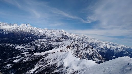
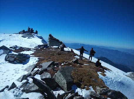

The Kedarkantha trek is a great option for both beginners and experienced trekkers, as it offers a mix of challenging and easy sections, and allows you to experience the beauty and culture of the region. It is recommended to be in good physical condition and to be properly equipped and acclimatized before embarking on the trek. It is also important to follow the guidelines and instructions of the trek leader and to be prepared for the high altitude and cold temperatures.
A Beginner’s Guide to Trekking in Kedarkantha
A Beginner’s Guide to Trekking in Kedarkantha include:
- Best time to go: The best time to go on the Kedarkantha trek is between the months of December and April, when the weather is relatively mild and the sky is clear, making it ideal for trekking and hiking. The temperature during this time can range from -10 to 10 degrees Celsius (14 to 50 degrees Fahrenheit) at the summit. It is important to be prepared for cold temperatures and to bring warm clothing and gear, such as thermal layers, a down jacket, gloves, and a warm hat.
- What to pack: It is important to pack light and only bring essential items on the trek. Some of the items that you should consider packing include a good pair of trekking shoes, a small backpack, a water bottle, a torch (flashlight), a hat, sunscreen, insect repellent, personal medical supplies, and a first aid kit. You should also bring warm clothing, such as thermal layers, a down jacket, gloves, and a warm hat, as the temperature can drop significantly at the high altitude.
- How to prepare for the high altitude: The Kedarkantha trek takes you to an elevation of 4,220 meters (13,850 feet) above sea level, and it is important to be properly acclimatized before attempting the trek. Some ways to prepare for the high altitude include gradually increasing your physical activity level, staying well-hydrated, and avoiding alcohol and tobacco. It is also important to listen to your body and to take breaks and rest if you feel tired or dizzy.
- Other tips and considerations: Some other tips and considerations for beginners planning to trek in Kedarkantha include booking a trek with a reputable trekking company, getting a thorough medical check-up before the trek, and carrying a photocopy of your identification documents. It is also important to follow the guidelines and instructions of the trek leader, and to be prepared for any unforeseen circumstances.
Exploring the Culture and History of Kedarkantha:
Exploring the Culture and History of Kedarkantha include:
- The importance of the mountain to the local community: Kedarkantha is a mountain in the western Himalayas of Uttarakhand, India. It is located in the Govind Wildlife Sanctuary, and is considered to be one of the most beautiful peaks in the region. The mountain is revered by the local community, and is believed to be the abode of the gods. It is also an important source of water for the region, as several streams and rivers originate from its glaciers.
- Temples and cultural sites: There are several temples and cultural sites that can be found along the Kedarkantha trek. Some of the notable ones include the Hargaon Temple, the Sankri Temple, and the Har ki Doon Temple. The Hargaon Temple is a small shrine located near the village of Hargaon, and is dedicated to Lord Shiva. The Sankri Temple is a small shrine located in the village of Sankri, and is dedicated to Lord Shiva and Lord Ganesha. The Har ki Doon Temple is a small shrine located in the village of Har ki Doon, and is dedicated to Lord Shiva.
- History and significance: The region surrounding Kedarkantha has a rich history and cultural significance. The area is home to several ancient temples, and was an important center of trade and commerce during the medieval period. The region is also home to several species of rare and endangered wildlife, including the snow leopard, the blue sheep, and the Himalayan musk deer. It is an important area for conservation, and is protected by the Govind Wildlife Sanctuary.
The Best Hikes in Kedarkantha:
The Best Hikes in Kedarkantha include:
- Difficulty level: The Kedarkantha trek is classified as a moderate to difficult trek, with a difficulty level of 3 out of 5. The trek involves a total distance of 20 kilometers (12.4 miles) and an elevation gain of 1,220 meters (4,000 feet). The trek can be physically demanding, and requires a good level of fitness. However, the trek can be done by anyone with a moderate level of fitness and a positive attitude, as long as they are properly acclimatized and well-prepared.
- Length and duration: The Kedarkantha trek takes place over a period of 5 days, and involves a total distance of 20 kilometers (12.4 miles). The trek starts from the village of Sankri, and takes you through the villages of Juda-Ka-Talab, Kedarkantha Base Camp, Hargaon, and finally, to the summit of Kedarkantha. Each day involves a hike of 4 to 8 kilometers (2.5 to 5 miles), and you will be camping in tents at designated campsites along the way.
- Scenery: The Kedarkantha trek takes you through some of the most beautiful and picturesque landscapes in the western Himalayas. You will be treated to stunning views of the surrounding mountain ranges, including the Swargarohini, Bandarpoonch, and Ranglana peaks. You will also pass through dense forests of pine and deodar trees, and walk along streams and rivers. The summit of Kedarkantha offers breathtaking views of the surrounding landscape, and on a clear day, you can see as far as the Gangotri and Yamunotri peaks.
How Difficult is the Kedarkantha Trek?
- Difficulty level: The Kedarkantha trek is classified as a moderate to difficult trek, with a difficulty level of 3 out of 5. The trek involves a total distance of 20 kilometers (12.4 miles) and an elevation gain of 1,220 meters (4,000 feet). The trek can be physically demanding, and requires a good level of fitness. However, the trek can be done by anyone with a moderate level of fitness and a positive attitude, as long as they are properly acclimatized and well-prepared.
- Terrain: The Kedarkantha trek takes you through a variety of terrains, including forests, meadows, streams, and rocky trails. The trek starts with a gentle climb through the forest, and gradually gets steeper as you approach the summit. The final stretch to the summit involves a steep climb over rocky terrain. The trek is mostly well-marked, but can be slippery and muddy at times, especially during the monsoon season. It is important to be careful and watch your step at all times.
- Elevation gain: The Kedarkantha trek involves an elevation gain of 1,220 meters (4,000 feet) from the base camp at Juda-Ka-Talab to the summit of Kedarkantha. The trek takes place over a period of 5 days, and the altitude gain is spread out over this period, allowing you to acclimatize slowly and reduce the risk of altitude sickness. However, it is still important to be aware of the symptoms of altitude sickness, and to take appropriate precautions, such as drinking plenty of water, avoiding alcohol, and getting enough rest.
Suggested Detailed Kedarkantha Trekking Itinerary:
Suggested Detailed Kedarkantha Trekking Itinerary could cover the following points:
- Day 1: Arrival at Dehradun and drive to Sankri (Base Camp). The trek starts from the village of Sankri, which is located about 200 kilometers (124 miles) from Dehradun. You can either drive to Sankri from Dehradun, or take a bus or taxi. The journey takes about 7-8 hours, and the road is mostly good, but can be winding and steep at times. Upon arrival at Sankri, you can check into your guesthouse or campsite, and spend the rest of the day exploring the village or relaxing.
- Day 2: Trek from Sankri to Juda-Ka-Talab. The trek starts from Sankri, and takes you through a dense pine forest to the campsite at Juda-Ka-Talab. The distance is about 7 kilometers (4.3 miles), and the trek takes about 5-6 hours. The trail is mostly gentle, with a few steep sections. The campsite is located near a small lake, and offers beautiful views of the surrounding mountains.
- Day 3: Trek from Juda-Ka-Talab to Kedarkantha Base Camp. The trek takes you from Juda-Ka-Talab to the base camp at Kedarkantha, which is located at an altitude of 3,850 meters (12,631 feet). The distance is about 7 kilometers (4.3 miles), and the trek takes about 5-6 hours. The trail is mostly gentle, with a few steep sections. The base camp is located in a clearing, and offers beautiful views of the surrounding mountains.
- Day 4: Summit day. The trek to the summit of Kedarkantha starts early in the morning, around 4-5 am. The distance is about 4 kilometers (2.5 miles), and the trek takes about 4-5 hours. The trail is steep and rocky, and requires some basic rock climbing skills. The summit of Kedarkantha is located at an altitude of 4,870 meters (15,979 feet), and offers breathtaking views of the surrounding peaks. After spending some time at the summit, you can retrace your steps back to the base camp.
- Day 5: Trek from Kedarkantha Base Camp to Sankri. The final day of the trek takes you back to Sankri, where you can check into your guesthouse or campsite, and spend the rest of the day relaxing or exploring the village.
- Additional days: You can add additional days to your trek if you want to explore the surrounding areas or visit nearby attractions, such as the Kedarkantha Temple, the Swargarohini Temple, or the Yamunotri Temple. You can also add a side trip to the Har Ki Dun valley or the Ruinsara lake.
Kedarkantha trek route
The Kedarkantha trek is a popular and relatively easy trek in the Garhwal region of the Himalayas in the Indian state of Uttarakhand. The trek typically starts from the base camp at Sankri, which is located in the Tons valley. From Sankri, the trek follows a well-marked trail through the Govind National Park, passing through dense forests and small villages along the way. The route then ascends to the Kedarkantha base camp, located at an elevation of 3,830 meters. From the base camp, the trek continues to the summit of Kedarkantha peak at an elevation of 4,220 meters, offering panoramic views of the surrounding Himalayan peaks. The trek then descends back to the base camp and returns to Sankri. The entire trek takes about 6-7 days to complete, depending on the pace of the group and any additional activities or sightseeing. The trek is usually completed in a clockwise direction, starting and ending in Sankri.
Gangotri and Yamunotri peaks
Gangotri and Yamunotri are two peaks located in the western Himalayas in the Indian state of Uttarakhand. Gangotri is the highest peak of the Gangotri Group of peaks, which is a subrange of the Garhwal Himalayas. It is located in the Uttarkashi district and has an elevation of 6,651 meters (21,792 feet). Yamunotri is the highest peak of the Bandarpunch Group of peaks, which is also a subrange of the Garhwal Himalayas. It is located in the Uttarkashi district and has an elevation of 6,315 meters (20,720 feet). Both Gangotri and Yamunotri are popular destinations for mountain climbing and trekking, and are considered to be sacred by Hindus. The Kedarkantha trek does not pass through either of these peaks, but they are located in the same region and can be visited as side trips from the trek.
Swargarohini, Bandarpoonch, and Ranglana peaks.
Swargarohini, Bandarpoonch, and Ranglana are three peaks located in the western Himalayas in the Indian state of Uttarakhand. Swargarohini is the highest peak of the Swargarohini Group of peaks, which is a subrange of the Garhwal Himalayas. It is located in the Uttarkashi district and has an elevation of 6,252 meters (20,506 feet). Bandarpoonch is the highest peak of the Bandarpunch Group of peaks, which is also a subrange of the Garhwal Himalayas. It is located in the Uttarkashi district and has an elevation of 6,316 meters (20,720 feet). Ranglana is a peak located in the Rudraprayag district of Uttarakhand. It has an elevation of 6,143 meters (20,176 feet). All three of these peaks are popular destinations for mountain climbing and trekking, and are considered to be challenging due to their high elevation and rugged terrain.
Juda-Ka-Talab, Kedarkantha Base Camp
Juda-Ka-Talab is a lake located in the Kedarkantha region of the Uttarakhand state in India. It is located at an altitude of 3,660 meters (12,010 feet) and is a popular destination for trekking and camping. The lake is surrounded by forests and meadows, and offers beautiful views of the surrounding mountain ranges.
The Kedarkantha base camp is the starting point for the Kedarkantha trek. It is located at an altitude of 2,100 meters (6,890 feet) and is a small village with a few guesthouses and campsites. The base camp is located near the Juda-Ka-Talab lake, and is the starting point for the trek to the Kedarkantha summit. From the base camp, trekkers can follow a well-marked trail through the forests and meadows of the Kedarkantha region, eventually reaching the summit at an altitude of 3,810 meters (12,500 feet). The trek typically takes 3-4 days to complete, depending on the route and pace of the trekker.
Bagji Bugyal Uttarakhand
Bagji Bugyal is a high altitude meadow located in the Chamoli district of Uttarakhand, India. It is situated at an altitude of 3,350 meters above sea level and is known for its natural beauty and serene surroundings. The meadow is surrounded by dense forests and is a popular destination for trekking and camping. The area is also home to a variety of flora and fauna, making it an attractive destination for nature enthusiasts.
A guide to planning a trip to Bagji Bugyal
- How to get there: The nearest airport to Bagji Bugyal is Jolly Grant Airport in Dehradun, which is about 272 kilometers away. From Dehradun, you can take a bus or hire a taxi to reach the meadow. The nearest railway station is Rishikesh, which is about 251 kilometers away. From Rishikesh, you can hire a taxi or take a bus to reach Bagji Bugyal.
- Where to stay: There are several hotels and guesthouses in the area that offer accommodation to visitors. You can also opt to camp in the meadow if you prefer a more rustic experience. Make sure to book your accommodation in advance, as the meadow can get quite busy during peak season.
- Things to do: There are many activities to enjoy in and around Bagji Bugyal. You can go trekking and explore the surrounding forests and mountains, or go camping and enjoy the beauty of the meadow. You can also visit the nearby temples and learn about the local culture and traditions.
- Tips for visiting: Make sure to bring warm clothing, as the temperature can drop significantly at night. It is also a good idea to carry a first aid kit and any necessary medications with you. It is important to respect the local customs and traditions, and to follow the rules and regulations of the area.
A profile of the local communities and culture in the area around Bagji Bugyal
The area around Bagji Bugyal is home to several local communities, each with its own unique culture and traditions. The Garhwali people, who belong to the Himalayan region of Uttarakhand, make up a significant portion of the population in the area. The Garhwali culture is rich and diverse, with a strong emphasis on tradition and community.
The Garhwali people are known for their hospitality and generosity, and visitors to the area are often welcomed into their homes and treated as guests of honor. The local cuisine is an integral part of the Garhwali culture, with dishes like ghughuti (a type of dumpling) and kauli (a spicy vegetable stew) being popular staples.
The area is also home to several temples and holy sites that are important to the local people. The Tungnath Temple, dedicated to the Hindu god Shiva, is a popular place of pilgrimage and is located near Bagji Bugyal. The temple is believed to be one of the highest Shiva temples in the world and is an important part of the local culture and traditions.
Overall, the area around Bagji Bugyal is rich in culture and offers visitors a unique opportunity to learn about and experience the way of life of the local communities.
A review of the best treks and hikes
- Tungnath Trek: This moderate trek takes you through beautiful forests and meadows to the Tungnath Temple, which is located at an altitude of 3,680 meters. The trek is suitable for beginners and takes about 3-4 days to complete. Make sure to carry warm clothing, as the temperature can drop significantly at higher altitudes.
- Chopta Chandrashila Trek: This moderate to difficult trek takes you to the Chandrashila peak, which offers stunning views of the Himalayan range. The trek takes about 3-4 days to complete and is suitable for experienced hikers. Make sure to acclimatize to the altitude before attempting this trek.
- Deoriatal Trek: This easy to moderate trek takes you through beautiful forests and meadows to the Deoriatal lake, which is located at an altitude of 2,437 meters. The trek takes about 2-3 days to complete and is suitable for beginners.
- Tips for hikers: It is important to be well-prepared for any trek or hike. Make sure to carry enough water and snacks, as well as a first aid kit and any necessary medications. Wear comfortable clothing and shoes, and always follow the rules and regulations of the area. It is also a good idea to inform someone of your itinerary and expected return time.
Flora and fauna of Bagji Bugyal
The region around Bagji Bugyal is home to a diverse range of flora and fauna, including several species that are unique to the area. The meadow itself is surrounded by dense forests, which are home to a variety of trees and plants, including oak, rhododendron, and deodar cedar.
The area is also home to a wide range of wildlife, including several species of birds and mammals. Some of the animals that can be found in the region include Himalayan black bear, musk deer, snow leopard, and red fox.
The biodiversity of the region is important for maintaining the ecological balance of the area and for supporting the local communities, who rely on the natural resources of the region for their livelihoods. It is therefore important to protect and preserve this biodiversity for future generations.
There are several ways in which we can protect the flora and fauna of the region:
- Practice responsible tourism: When visiting the area, make sure to respect the local customs and traditions, and to follow the rules and regulations of the area. Avoid littering and do not disturb the local wildlife.
- Support conservation efforts: There are several organizations and initiatives working to protect the biodiversity of the region. You can support their efforts by donating time or money, or by volunteering your services.
- Educate others: Spread awareness about the importance of protecting the biodiversity of the region, and encourage others to adopt sustainable practices that support the conservation of the local flora and fauna.
Suggest detailed Bagji Bugyal Trekking Itinerary
Here is a suggested 3-day trekking itinerary for Bagji Bugyal:
Day 1:
- Begin the trek from the base camp at Lohajung.
- Trek through forests and meadows to the first campsite at Didna Village.
- The trek is moderate in difficulty and takes about 6-7 hours to complete.
- Overnight stay at the campsite.
Day 2:
- Continue the trek from Didna Village to Bagji Bugyal.
- The trek takes about 5-6 hours to complete and is moderate in difficulty.
- Enjoy the beauty of the meadow and set up camp for the night.
Day 3:
- Hike to the nearby Tungnath Temple, which is located at an altitude of 3,680 meters.
- The hike takes about 3-4 hours to complete and is moderate in difficulty.
- Return to Bagji Bugyal for overnight stay.
Day 4:
- Begin the return journey to Lohajung.
- The trek takes about 5-6 hours to complete and is moderate in difficulty.
- Arrive at the base camp in the evening.
Some highlights Bagji Bugyal
- Trekking through the beautiful forests and meadows of the area.
- Camping in the meadow and enjoying the peace and quiet of the natural surroundings.
- Visiting the nearby temples and learning about the local culture and traditions.
- Taking in the stunning views of the Himalayan range from the meadow.
Some challenges that one might face on a trip to Bagji Bugyal might include:
- Adjusting to the high altitude, which can cause symptoms like dizziness, nausea, and difficulty breathing.
- Dealing with inclement weather, which can be unpredictable in the mountains.
- Finding accommodation and transportation, which can be limited in the area.
Overall, a trip to Bagji Bugyal is likely to be a unique and memorable experience, and one that offers a chance to connect with nature and learn about the local culture and traditions.
Panar Bugyal
Panar Bugyal is a high altitude meadow located in the Chamoli district of Uttarakhand, India. It is situated at an altitude of 3,400 meters above sea level and is known for its natural beauty and serene surroundings. The meadow is surrounded by dense forests and is a popular destination for trekking and camping. The area is also home to a variety of flora and fauna, making it an attractive destination for nature enthusiasts.
A guide to planning a trip to Panar Bugyal
- How to get there: The nearest airport to Panar Bugyal is Jolly Grant Airport in Dehradun, which is about 272 kilometers away. From Dehradun, you can take a bus or hire a taxi to reach the meadow. The nearest railway station is Rishikesh, which is about 251 kilometers away. From Rishikesh, you can hire a taxi or take a bus to reach Panar Bugyal.
- Where to stay: There are several hotels and guesthouses in the area that offer accommodation to visitors. You can also opt to camp in the meadow if you prefer a more rustic experience. Make sure to book your accommodation in advance, as the meadow can get quite busy during peak season.
- Things to do: There are many activities to enjoy in and around Panar Bugyal. You can go trekking and explore the surrounding forests and mountains, or go camping and enjoy the beauty of the meadow. You can also visit the nearby temples and learn about the local culture and traditions.
- Tips for visiting: Make sure to bring warm clothing, as the temperature can drop significantly at night. It is also a good idea to carry a first aid kit and any necessary medications with you. It is important to respect the local customs and traditions, and to follow the rules and regulations of the area.
Beauty of Panar Bugyal and its surroundings
Panar Bugyal is a high altitude meadow located in the Chamoli district of Uttarakhand, India. It is situated at an altitude of 3,400 meters above sea level and is known for its natural beauty and serene surroundings. The meadow is surrounded by dense forests and is a popular destination for trekking and camping.
The meadow itself is a vast expanse of lush green grass, dotted with wildflowers of various colors. The surrounding forests are a riot of colors, with the trees displaying a range of hues as the seasons change. The air is crisp and clean, and the silence is broken only by the sound of birds and the occasional rustling of leaves.
The views from the meadow are breathtaking, with the Himalayan range forming a picturesque backdrop. On a clear day, you can see the peaks of Nanda Devi and Trishul in the distance. The sunrise and sunset are especially beautiful, with the rays of the sun casting a golden glow over the landscape.
Overall, Panar Bugyal is a place of great natural beauty, and a visit to the meadow is sure to be a memorable and rewarding experience.
Local communities and culture around Panar Bugyal
The area around Panar Bugyal is home to several local communities, each with its own unique culture and traditions. The Garhwali people, who belong to the Himalayan region of Uttarakhand, make up a significant portion of the population in the area. The Garhwali culture is rich and diverse, with a strong emphasis on tradition and community.
The Garhwali people are known for their hospitality and generosity, and visitors to the area are often welcomed into their homes and treated as guests of honor. The local cuisine is an integral part of the Garhwali culture, with dishes like ghughuti (a type of dumpling) and kauli (a spicy vegetable stew) being popular staples.
The area is also home to several temples and holy sites that are important to the local people. The Tungnath Temple, dedicated to the Hindu god Shiva, is a popular place of pilgrimage and is located near Panar Bugyal. The temple is believed to be one of the highest Shiva temples in the world and is an important part of the local culture and traditions.
Overall, the area around Panar Bugyal is rich in culture and offers visitors a unique opportunity to learn about and experience the way of life of the local communities.
Best treks and hikes Panar Bugyal
- Tungnath Trek: This moderate trek takes you through beautiful forests and meadows to the Tungnath Temple, which is located at an altitude of 3,680 meters. The trek is suitable for beginners and takes about 3-4 days to complete. Make sure to carry warm clothing, as the temperature can drop significantly at higher altitudes.
- Chopta Chandrashila Trek: This moderate to difficult trek takes you to the Chandrashila peak, which offers stunning views of the Himalayan range. The trek takes about 3-4 days to complete and is suitable for experienced hikers. Make sure to acclimatize to the altitude before attempting this trek.
- Deoriatal Trek: This easy to moderate trek takes you through beautiful forests and meadows to the Deoriatal lake, which is located at an altitude of 2,437 meters. The trek takes about 2-3 days to complete and is suitable for beginners.
- Tips for hikers: It is important to be well-prepared for any trek or hike. Make sure to carry enough water and snacks, as well as a first aid kit and any necessary medications. Wear comfortable clothing and shoes, and always follow the rules and regulations of the area. It is also a good idea to inform someone of your itinerary and expected return time.
History and mythology of Panar Bugyal
Panar Bugyal is a high altitude meadow located in the Chamoli district of Uttarakhand, India. It is situated at an altitude of 3,400 meters above sea level and is known for its natural beauty and serene surroundings. The meadow is surrounded by dense forests and is a popular destination for trekking and camping.
According to local folklore, the meadow is believed to be the site of a miraculous healing spring. Legend has it that the spring has the power to cure ailments and diseases, and many people visit the meadow in search of healing.
The meadow is also associated with several myths and legends. One such legend is that the meadow was once the home of a powerful yogi (ascetic) who had the power to control the weather. It is said that the yogi used his powers to protect the meadow from storms and natural disasters, and that the meadow remains blessed to this day.
Best campsites and outdoor adventure activities in Panar Bugyal
The area around Panar Bugyal offers a variety of campsites and outdoor adventure activities for visitors to enjoy. Here is a round-up of some of the best options:
- Camping: The meadow itself is a great place to set up camp and enjoy the beauty of the surroundings. There are also several campsites in the area that offer amenities like tents and sleeping bags for rent.
- Trekking: The area around Panar Bugyal is home to a variety of treks that cater to hikers of all levels of experience. Some popular options include the Tungnath Trek, the Chopta Chandrashila Trek, and the Deoriatal Trek.
- Rock climbing: The area around Panar Bugyal is home to several cliffs and rock faces that are suitable for rock climbing. There are several local guides and organizations that offer rock climbing expeditions for visitors.
- Rafting: The Alaknanda River, which flows through the region, is a popular destination for rafting. There are several local operators that offer rafting expeditions for visitors.
- Wildlife watching: The area around Panar Bugyal is home to a variety of wildlife, including several species of birds and mammals. You can go on a wildlife watching tour to spot animals like Himalayan black bear, musk deer, snow leopard, and red fox.
Suggested Detailed Panar Bugyal Trekking Itinerary
Day 1: Arrival at Joshimath
- Reach Joshimath by bus or taxi from Rishikesh or Dehradun.
- Check into a hotel or guesthouse in Joshimath.
- Acclimatize and rest for the day.
Day 2: Drive to Lohajung and trek to Didna Village
- Take a shared taxi or hire a private taxi to reach Lohajung.
- Start the trek from Lohajung to Didna Village.
- The trek to Didna Village is around 8 kilometers and takes around 3-4 hours to complete.
- The trail passes through forests and meadows and offers stunning views of the surrounding mountains.
- Reach Didna Village and check into a guesthouse.
Day 3: Trek to Ali Bugyal
- Start the trek from Didna Village to Ali Bugyal.
- The trek to Ali Bugyal is around 10 kilometers and takes around 5-6 hours to complete.
- The trail passes through forests and meadows and offers stunning views of the surrounding mountains.
- Reach Ali Bugyal and set up camp for the night.
Day 4: Trek to Panar Bugyal
- Start the trek from Ali Bugyal to Panar Bugyal.
- The trek to Panar Bugyal is around 9 kilometers and takes around 4-5 hours to complete.
- The trail passes through forests and meadows and offers stunning views of the surrounding mountains.
- Reach Panar Bugyal and set up camp for the night.
Day 5: Explore Panar Bugyal and return to Lohajung
- Spend the day exploring Panar Bugyal and taking in the stunning views of the surrounding mountains.
- In the afternoon, start the trek back to Lohajung
Stay In Panar Bugyal
- Camping: Panar Bugyal is a popular spot for camping, and there are several campsites in the region that offer tents and other camping equipment for rent. You can also bring your own camping gear and pitch a tent in a secluded spot in the meadow.
- Homestays: There are several homestays in the region surrounding Panar Bugyal that offer basic accommodation facilities. Homestays are a good option if you are looking for a budget-friendly option and want to experience local hospitality.
- Hotels: There are a few hotels in the region surrounding Panar Bugyal that offer comfortable accommodation facilities. These hotels usually have basic amenities such as electricity, hot water, and basic meals.


